 Filter: Categories of Wisconsin Historical Images
Filter: Subject of Prairies
Filter: Subject of land use, rural
Filter: Categories of Wisconsin Historical Images
Filter: Subject of Prairies
Filter: Subject of land use, rural

| Date: | 1755 |
|---|---|
| Description: | Map of Virginia and parts of Maryland, North Carolina, and New Jersey. It shows borders, boundary lines, some Native American land, counties, cities, towns... |
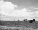
| Date: | 06 30 1955 |
|---|---|
| Description: | From caption: "Prairie two miles north of Montfort Wis on the Iowa-Grant County line trunk highway I view to the east from the road. Photo by Robert Hall 1... |
If you didn't find the material you searched for, our Library Reference Staff can help.
Call our reference desk at 608-264-6535 or email us at:
