 Filter: Categories of Wisconsin Historical Images
Filter: Subject of Prairies
Filter: Subject of land
Filter: Subject of land use
Filter: Categories of Wisconsin Historical Images
Filter: Subject of Prairies
Filter: Subject of land
Filter: Subject of land use

| Date: | 1920 |
|---|---|
| Description: | Upland prairie farming country with a view of the fields. |
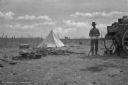
| Date: | |
|---|---|
| Description: | View of a camp with a cook standing at the back end of a chuckwagon with a large bowl in front of him. To the left is a pile of logs, along with some pots.... |

| Date: | 1925 |
|---|---|
| Description: | Elevated view of Mount Vernon from the a grassy hill. |

| Date: | 1974 |
|---|---|
| Description: | This 1974 map is a reproduction of the original survey maps of the Four Lakes region of Dane County, Wisconsin. It shows sections, lakes, rivers, wetlands,... |

| Date: | 1838 |
|---|---|
| Description: | This map is a development plat that shows street names, numbered blocks and lots, and small farm lot owners. Included on the right of the map is a large am... |

| Date: | 1986 |
|---|---|
| Description: | Nuclear Missile Silo Vigil & Requiem. Hundreds of people surround the fence, holding hands, in opposition to the new MX missiles being installed, missiles ... |
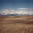
| Date: | 1986 |
|---|---|
| Description: | View across valley towards missile silo, Minuteman F-8. In the foreground is prairie, in the far background are snow-capped mountains and foothills. This... |

| Date: | 1755 |
|---|---|
| Description: | Map of Virginia and parts of Maryland, North Carolina, and New Jersey. It shows borders, boundary lines, some Native American land, counties, cities, towns... |
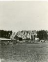
| Date: | 1886 |
|---|---|
| Description: | View across field towards a farm, with farmhouse, barn, outbuildings, and fences. The photograph appeared in Joseph Schafer's 1932 book The Wisconsin Le... |
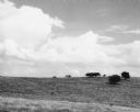
| Date: | 06 30 1955 |
|---|---|
| Description: | From caption: "Prairie two miles north of Montfort Wis on the Iowa-Grant County line trunk highway I view to the east from the road. Photo by Robert Hall 1... |

| Date: | 06 1950 |
|---|---|
| Description: | View across a gently sloping prairie field. Trees are in the distance, and power lines and a road are on the left. The Highway Commission descriptive remar... |
If you didn't find the material you searched for, our Library Reference Staff can help.
Call our reference desk at 608-264-6535 or email us at:
