 Filter: Categories of Wisconsin Historical Images
Filter: Subject of Postal service
Filter: Year of 1900-1999
Filter: Subject of education
Filter: Categories of Wisconsin Historical Images
Filter: Subject of Postal service
Filter: Year of 1900-1999
Filter: Subject of education

| Date: | 03 23 1932 |
|---|---|
| Description: | A man is leading Dudgeon School children through the mail sorting area on their tour of the post office. |

| Date: | 1953 |
|---|---|
| Description: | Two children are exiting an International R-183 School Bus. The children are greeted by a woman, possibly their mother. A man, possibly the father of the c... |
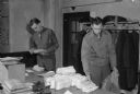
| Date: | 02 24 1944 |
|---|---|
| Description: | Private William Huneke and Sargeant Harold Gleaves checking in a stack of mail from soldiers and sailors at the fighting fronts of the world for the United... |

| Date: | 06 15 1948 |
|---|---|
| Description: | Four Randall School third grade students mail a package containing a scrapbook of stories, poems, art work and photos. It will go to a third grade class in... |

| Date: | 1902 |
|---|---|
| Description: | A map of Milwaukee County, Wisconsin that shows the township and range system, sections, towns, roads, railroads and rail stations, cities and villages, po... |

| Date: | 1903 |
|---|---|
| Description: | This 1903 map of Outagamie County, Wisconsin, shows the township and range grid, towns, sections, cities and villages, landownership and acreages, rural ma... |

| Date: | 1914 |
|---|---|
| Description: | This map of Price County, Wisconsin, from the early 20th century shows land for sale by the Homemaker Land Company of Milwaukee. The township and range sys... |

| Date: | 1911 |
|---|---|
| Description: | This 1911 map shows the Post Office's rural routes in Racine County, Wisconsin, and portions of eastern Walworth and northern Kenosha counties. The locatio... |

| Date: | 1903 |
|---|---|
| Description: | This map of Richland County, Wisconsin, shows land ownership and acreages, the township and range grid, sections, cities, towns and post offices, roads, ra... |

| Date: | 1917 |
|---|---|
| Description: | This map, which highlights the land for sale by the Rust-Owen Lumber Company in the towns of Drummond, Cable and Grandview, Bayfield County, Wisconsin, sho... |

| Date: | 1906 |
|---|---|
| Description: | This map of Sheboygan County, Wisconsin, from the early 20th century shows school districts and school locations in the county. Also shown are the township... |

| Date: | 1909 |
|---|---|
| Description: | This 1909 revision of Harmon's 1896 map of Washburn County, Wisconsin, shows the township and range grid, towns, sections, schools, wagon roads, cities and... |

| Date: | 1916 |
|---|---|
| Description: | This 1916 map of Washburn County, Wisconsin, shows the township and range grid, sections, towns, schools, wagon roads, cities and villages, post offices, s... |

| Date: | 1906 |
|---|---|
| Description: | This 1906 map of Bayfield County, Wisconsin, shows towns, sections, cities, villages and post offices, land ownership, wagon roads, railroads, schools, gov... |

| Date: | 1903 |
|---|---|
| Description: | Map of Brown County, Wisconsin, shows the township and range grid, towns, sections, cities, villages and post offices, land owners and acreages, railroads,... |

| Date: | 1901 |
|---|---|
| Description: | Map shows lakes, rivers, schools, saw mills, post offices, creameries, and churches. Includes significant manuscript annotations showing township divisions... |

| Date: | 1902 |
|---|---|
| Description: | This 1902 map of Chippewa County, Wisconsin, shows the township and range grid, towns, sections, cities, villages and post offices, land ownership and acre... |

| Date: | 1910 |
|---|---|
| Description: | Map shows routes, post offices, houses, churches, roads, and schools."June 1, 1910. E.G."Blue line print."Walworth Co., Wis. 451" -- bottom margin. |

| Date: | 1910 |
|---|---|
| Description: | This 1910 map from the U.S. Post Office Dept. shows rural delivery routes, active and discontinued post offices, collection boxes, selected rural landowner... |

| Date: | 1911 |
|---|---|
| Description: | This 1911 map from the U.S. Post Office Dept. shows rural delivery routes, active and discontinued post offices, selected rural landowners and houses, chur... |
If you didn't find the material you searched for, our Library Reference Staff can help.
Call our reference desk at 608-264-6535 or email us at: