 Filter: Categories of Wisconsin Historical Images
Filter: Subject of Postal service
Filter: Year of 1900-1999
Filter: Subject of cities and towns
Filter: Categories of Wisconsin Historical Images
Filter: Subject of Postal service
Filter: Year of 1900-1999
Filter: Subject of cities and towns

| Date: | 1911 |
|---|---|
| Description: | This 1911 map from the U.S. Post Office Department shows rural delivery routes, active and discontinued post offices, selected rural landowners and houses,... |

| Date: | 1907 |
|---|---|
| Description: | Shows post offices, railroads, country clubs, and land ownership by name. Also shows the cities of Lake Geneva and Delavan and Lake Como. "Suggestions for ... |
| Date: | 1910 |
|---|---|
| Description: | Shows roads, railroads, post offices, schools, houses, churches, and routes. Includes distant chart and explanation. "Price 35 cents"--Upper left margin. "... |

| Date: | 1911 |
|---|---|
| Description: | Shows roads, railroads, post offices, schools, houses, churches, and routes. Includes distant chart and explanation. "Price 35 cents"--Upper left margin. "... |
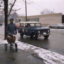
| Date: | 1970 |
|---|---|
| Description: | An African-American postal carrier is standing on the sidewalk with mail in a rolling cart. He is wearing a winter postal employee uniform and a hat. Behin... |
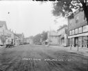
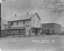
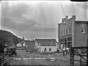
| Date: | 1927 |
|---|---|
| Description: | Street scene down middle of street, with businesses on both sides. A hotel, the post office, and a hardware store are on the left. A mercantile, ice cream ... |
| Date: | 1921 |
|---|---|
| Description: | View across street towards the row of businesses along the sidewalk on the right. Includes, from the right, a man in an apron, and three young girls standi... |
| Date: | 1922 |
|---|---|
| Description: | View across street of commercial buildings, with a tree-lined hill in the far background. A group of men and women are standing on the porch of the brick b... |

| Date: | 1918 |
|---|---|
| Description: | View down street of the central business district. A large brick building on the left with awnings includes a furniture store. Automobiles are parked at an... |
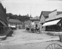
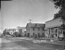
| Date: | 1909 |
|---|---|
| Description: | View down Main Street. On the right is a general store, and Livery/Hardware building with horse-drawn carts parked in the street in front. A group of men a... |
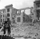
| Date: | 09 18 1944 |
|---|---|
| Description: | Two soldiers in the lower left look at a map. Behind them is what remains of the Brest Post Office. Just under the decorative stone cornice at the top is t... |

| Date: | 1911 |
|---|---|
| Description: | View from street towards a building housing the post office and bank, which are on the main floor at the top of a flight of steps. A datestone above one of... |

| Date: | 1912 |
|---|---|
| Description: | Three-quarter view from front of a group of men sitting in an Internatioal bus which is parked at the curb near what appears to be an International Harvest... |
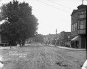
| Date: | 1911 |
|---|---|
| Description: | View down middle of unpaved Main Street. There are large trees along the sidewalk on the left. Businesses line both sides of the street, and there is a sta... |

| Date: | 1910 |
|---|---|
| Description: | Map shows routes, post offices, churches, schools, houses, and roads on the rural delivery service route in blue lines. An explanation key appears on the l... |

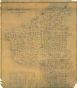
| Date: | 1904 |
|---|---|
| Description: | Map shows townships and sections, landownership and acreages, roads, railroads, post offices, and farms. On the top, bottom, and sides of map are advertise... |

| Date: | 1914 |
|---|---|
| Description: | Map shows townships, schools, saw mills, roads, railroads, and post offices. Text on the top left has a box of towns with land in Marathon County. Top righ... |

| Date: | 1901 |
|---|---|
| Description: | Map shows townships, schools, creameries, post offices, and roads. The left side of the map features a legend with symbols for points of interest. |
| Date: | 1921 |
|---|---|
| Description: | A view of the central business district from the end of a bridge. The post office on the right with a small group of men and children in front. An automobi... |
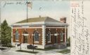
| Date: | 1910 |
|---|---|
| Description: | Colorized postcard of a slightly elevated view of the post office. There are wide front steps up to the arched entrance from the sidewalk. The arched entra... |
If you didn't find the material you searched for, our Library Reference Staff can help.
Call our reference desk at 608-264-6535 or email us at: