 Filter: Categories of Wisconsin Historical Images
Filter: Subject of Postal service
Filter: County of Milwaukee
Filter: Subject of roads
Filter: Categories of Wisconsin Historical Images
Filter: Subject of Postal service
Filter: County of Milwaukee
Filter: Subject of roads
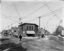
| Date: | 08 31 1910 |
|---|---|
| Description: | Looking northwest on Fond du Lac Avenue from W. Walnut Street. In the center is a building with awning that reads: "1220 Zautcke Bros." Streetcars, pedestr... |

| Date: | |
|---|---|
| Description: | Elevated view of the government building with a tower on a street corner. Pedestrians are on the sidewalk in front. Caption reads: "Government Building and... |
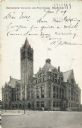
| Date: | 1909 |
|---|---|
| Description: | Building with tower from street level. Two flags fly are on top of the building. Caption reads: "Government Building and Post Office, Milwaukee." |
| Date: | |
|---|---|
| Description: | View from across the street with pedestrians walking on the sidewalk in front. Caption reads: "Post Office, Milwaukee, Wis." |
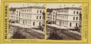
| Date: | 1880 |
|---|---|
| Description: | Stereograph. Elevated view of corner of Milwaukee and Wisconsin Streets. Three-story white building with several chimneys. A horse and cart are on the rig... |

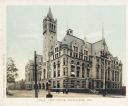
| Date: | 1910 |
|---|---|
| Description: | Exterior view of post office, with tower on left side. Pedestrians are on the sidewalk at the corner. Caption reads: "Post Office and Government Bldg., Mil... |

| Date: | 1931 |
|---|---|
| Description: | The tower of the building is on the right, with flag poles at various peaks on the roof. On the right across the street is a building with classical style ... |

| Date: | 1858 |
|---|---|
| Description: | An ink on paper map of Milwaukee County and the eastern portion of Waukesha County that shows the townships of Oak Creek, Franklin, Greenfield, Wauwatosa, ... |

| Date: | 1886 |
|---|---|
| Description: | A hand-colored map of Milwaukee County, Wisconsin that shows the township and range system, sections, towns, roads, railroads and rail stations, cities and... |

| Date: | 1891 |
|---|---|
| Description: | A hand-colored map of Milwaukee County, Wisconsin that shows the township and range system, sections, towns, roads, railroads and rail stations, cities and... |

| Date: | 1896 |
|---|---|
| Description: | A map of Milwaukee County, Wisconsin that shows the township and range system, sections, towns, roads, railroads and rail stations, cities and villages, po... |

| Date: | 1902 |
|---|---|
| Description: | A map of Milwaukee County, Wisconsin that shows the township and range system, sections, towns, roads, railroads and rail stations, cities and villages, po... |

| Date: | 1886 |
|---|---|
| Description: | Map shows townships, post offices, roads, railroads, and selected buildings. The sections are in pink, green, blue, and yellow. Counties, towns, and lakes ... |

| Date: | 1894 |
|---|---|
| Description: | This map shows railroads, street railways, roads, wards, block numbers, parks, Lake Michigan, and one mile concentric circles indicating distance from the ... |

| Date: | 1900 |
|---|---|
| Description: | This map shows landownership, railroads, roads, churches, schools, cemeteries, post offices, townships, city wards, Lake Michigan, and rivers. The map incl... |
If you didn't find the material you searched for, our Library Reference Staff can help.
Call our reference desk at 608-264-6535 or email us at: