 Filter: Categories of Wisconsin Historical Images
Filter: Subject of Postal service
Filter: Type of Map or Atlas
Filter: County of Sheboygan
Filter: Categories of Wisconsin Historical Images
Filter: Subject of Postal service
Filter: Type of Map or Atlas
Filter: County of Sheboygan

| Date: | 1862 |
|---|---|
| Description: | This 1862 map of Sheboygan County, Wisconsin, shows land ownership and acreages, the township and range grid, towns, cities and villages, roads, railroads,... |

| Date: | 1906 |
|---|---|
| Description: | This map of Sheboygan County, Wisconsin, from the early 20th century shows school districts and school locations in the county. Also shown are the township... |
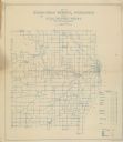
| Date: | 1911 |
|---|---|
| Description: | Shows routes, post offices, churches, houses, schools, roads, and collection boxes. "B. Oct. 11, 1911." Blue line print. "Sheboygan Co., Wis. 587." |
If you didn't find the material you searched for, our Library Reference Staff can help.
Call our reference desk at 608-264-6535 or email us at: