 Filter: Categories of Wisconsin Historical Images
Filter: Subject of Ponds
Filter: Year of 1900-1999
Filter: Categories of Wisconsin Historical Images
Filter: Subject of Ponds
Filter: Year of 1900-1999
| Date: | 1939 |
|---|---|
| Description: | Shirley and Robert Krueger standing barefoot at the edge of a pond. Their shoes and socks are lying on rocks at the waters edge. Shirley is holding a bow w... |

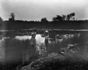
| Date: | 1909 |
|---|---|
| Description: | View across river toward the mill and dam. Caption reads: "Glen Lock Dam and Mill, Chippewa Falls, Wis." |

| Date: | 1950 |
|---|---|
| Description: | View across water of the Washington Monument from the Constitution Gardens Pond. |

| Date: | 1950 |
|---|---|
| Description: | View across water of the Washington Monument from the Constitution Gardens Pond. |
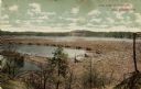
| Date: | 1910 |
|---|---|
| Description: | A colored photographic postcard view of a large log jam in the Dells Pond at Eau Claire. There are "booms" and several men standing on logs. Caption reads:... |

| Date: | 1961 |
|---|---|
| Description: | View of a group of people picnicking in a park at a picnic table. Plastic silverware, paper cups and plates, and a box of potato chips sit on top of the ta... |

| Date: | 06 06 1961 |
|---|---|
| Description: | Stanley Herrling (left), his wife, and sons Greg and Mark are each standing next to a horse at a fence bordering the pasture. This is one of a series of ph... |

| Date: | 06 06 1961 |
|---|---|
| Description: | Mark Herrling swimming in the spring-fed pool on the Stanley Herrling farm. This is one of a series of photographs of a rural Cross Plains farm which was p... |

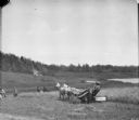
| Date: | 06 06 1961 |
|---|---|
| Description: | Stanley Herrling pulling in a rainbow trout from the trout pond. This is one of a series of photographs of a rural Cross Plains farm which was purchased 6 ... |

| Date: | 1962 |
|---|---|
| Description: | This blue print map shows 5 zoning districts, as well as lot and block numbers and dimensions, public land, streets, and Mill Pond. The zones are: "Single ... |

| Date: | 1959 |
|---|---|
| Description: | This map shows some land ownership, lot and block numbers, additions, fair grounds, streets, and railroads and is indexed. Mullet River and Mill Pond are l... |

| Date: | 08 20 1961 |
|---|---|
| Description: | Pond with lily pads at the intersection of Highways 131 and 60 on a foggy morning. In the background are hills shrouded in mist. |

| Date: | 1900 |
|---|---|
| Description: | View across grounds towards a pond. On the other side of the pond is a large glass building, probably a conservatory. There is a tall brick chimney next to... |

| Date: | 1900 |
|---|---|
| Description: | Elevated view from hill looking down at a lagoon and farm buildings. People are posing in a horse-drawn carriage on the far shoreline. More people are on h... |
| Date: | 1900 |
|---|---|
| Description: | Men are working in a field near a man using a horse-drawn McCormick binder. People are watching at the edge of the field in the background. On a hill above... |
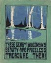
| Date: | 1910 |
|---|---|
| Description: | Watercolor design for a conservation poster made by a Wisconsin high school student as part of a competition. The poster has an image of birch trees on the... |

| Date: | 1937 |
|---|---|
| Description: | This is map 1 from a set of 4 taken from an atlas. The map shows streets, neighborhoods and proposed subdivision. Lake Michigan, Algoma Outer Harbor, the A... |

| Date: | 1912 |
|---|---|
| Description: | Marinette County, Township 36 N., Range 20 E. |

| Date: | 1912 |
|---|---|
| Description: | Marinette County, Fract. Township 37 N., Ranges 21 and 22 E. |

| Date: | 1900 |
|---|---|
| Description: | This map shows logging roads, railroads with spur lines, trails, rapids, lumber camps, Indian villages, summer resort, lakes, rivers, and ponds. |
If you didn't find the material you searched for, our Library Reference Staff can help.
Call our reference desk at 608-264-6535 or email us at: