 Filter: Categories of Wisconsin Historical Images
Filter: Subject of Ponds
Filter: Subject of transportation
Filter: Year of 1800-1899
Filter: Categories of Wisconsin Historical Images
Filter: Subject of Ponds
Filter: Subject of transportation
Filter: Year of 1800-1899

| Date: | 1874 |
|---|---|
| Description: | Bird's-eye map of Chippewa Falls. |

| Date: | 1879 |
|---|---|
| Description: | Bird's-eye view of Viroqua, county seat of Vernon County. |

| Date: | 1892 |
|---|---|
| Description: | Bird's-eye view of the Columbian Exposition pavilions from the vantage point of Lake Michigan. Included is an inset of the Union Passenger Station (now Uni... |
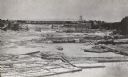
| Date: | 1866 |
|---|---|
| Description: | Elevated view taken from the extreme end of Clark's Saw and Planing Mill. An old flour mill can be seen behind the bridge, and to the extreme right are thr... |
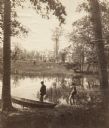
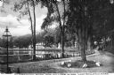
| Date: | 1870 |
|---|---|
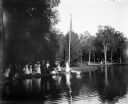
| Description: | Two men are in the foreground on a shoreline, one standing in a boat. In the background on the other shoreline are adults and children sitting in the gras... |
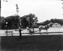
| Date: | 1899 |
|---|---|
| Description: | A male grounds keeper is driving a horse-drawn mower down a path on a park or estate grounds. Another man is leaning against a slender tree. Both men are w... |
| Date: | 1893 |
|---|---|
| Description: | Cyanotype scenic view of the 1893 Chicago World's Columbian Exposition grounds showing the U.S. Government Building and a bridge over the lagoon. |

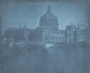
| Date: | 1893 |
|---|---|
| Description: | Cyanotype view of the Illinois Building at Chicago's World's Columbian Exposition showing a gondola and motor launch on the lagoon near a bridge. A wing of... |
| Date: | 1893 |
|---|---|
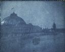
| Description: | A cyanotype view of the Horticulture Building at the World's Columbian Exposition with the dome of the Illinois Building in the background. There is a mot... |
| Date: | 1893 |
|---|---|
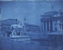
| Description: | A cyanotype view of the central basin, Peristyle and Statue of the Republic. There are several boats on the basin. On the right is a large statue of a bu... |
| Date: | 1893 |
|---|---|
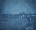
| Description: | A cyanotype view across lagoon from shoreline of the U.S. Government Building (right), and the Fisheries building (left). There is a bridge over the lagoon... |
| Date: | 1893 |
|---|---|
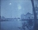
| Description: | A cyanotype view of the World's Columbian Exposition grounds from near the North Loop elevated railway station, showing the glass dome of the Horticulture ... |
| Date: | 1893 |
|---|---|
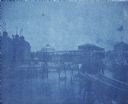
| Description: | A cyanotype view of the Agriculture Building (right) and Manufactures and Liberal Arts Building (left) from the bank of the South Canal at the World's Colu... |
| Date: | 07 30 1899 |
|---|---|
| Description: | View across pond of Syl at Soldiers Home with aunt Helen standing on a landing near a boat and a flagpole. There is a large group of people gathered around... |
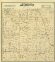
| Date: | 1873 |
|---|---|
| Description: | Columbia County Atlas Arlington Township 10 North Range 9 East. |
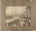
| Date: | 1893 |
|---|---|
| Description: | A view of the World's Columbian Exposition mounted on a cardboard album page, looking east from the Transportation Building. On the right are the Mines Bui... |

| Date: | 1866 |
|---|---|
| Description: | View of earthworks at the battlefield at Resacca. Dirt roads cross the field in the distance, leading to a farm and what appears to be a river. Plate 22... |

| Date: | 10 1884 |
|---|---|
| Description: | Sanborn insurance map of Black River Falls covering the area bordered by the Black River on the East, 3rd Street on the West, Johnson Street on the North, ... |
| Date: | 1899 |
|---|---|
| Description: | A man steers a horse and carriage down a winding country road near Clarendon Pond. Village dwellings are visible across the pond. |
If you didn't find the material you searched for, our Library Reference Staff can help.
Call our reference desk at 608-264-6535 or email us at:
