 Filter: Categories of Wisconsin Historical Images
Filter: Subject of Ponds
Filter: Subject of transportation
Filter: County of Walworth
Filter: Categories of Wisconsin Historical Images
Filter: Subject of Ponds
Filter: Subject of transportation
Filter: County of Walworth
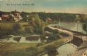
| Date: | 1905 |
|---|---|
| Description: | Elevated view of a pond, a stream, and a lake, with a road dividing the pond and stream from the lake. Industrial buildings and a smokestack are in the bac... |

| Date: | 1900 |
|---|---|
| Description: | Pen and pencil on tracing paper. Shows landownership by name, local streets, local businesses, mill pond, creek, and proposed railroad. |

| Date: | 1930 |
|---|---|
| Description: | This map has relief shown pictorially and shows plat of the city, block numbers, land ownership by name, local streets, railroads, mill pond, and part of G... |

| Date: | 1962 |
|---|---|
| Description: | This blue print map shows 5 zoning districts, as well as lot and block numbers and dimensions, public land, streets, and Mill Pond. The zones are: "Single ... |

| Date: | |
|---|---|
| Description: | View of a man driving an automobile down a road, approaching a wooden bridge over a stream next to a pond. Dwellings are on the slope of a hill in the back... |
If you didn't find the material you searched for, our Library Reference Staff can help.
Call our reference desk at 608-264-6535 or email us at: