 Filter: Categories of Wisconsin Historical Images
Filter: Subject of Ponds
Filter: Subject of marshes
Filter: Categories of Wisconsin Historical Images
Filter: Subject of Ponds
Filter: Subject of marshes
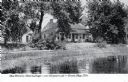
| Date: | 1907 |
|---|---|
| Description: | View across water toward the Tank Cottage. Caption reads: "The Historic Tank Cottage — over 100 years old — Green Bay, Wis." |

| Date: | |
|---|---|
| Description: | A peaceful view of a pond and mill, featuring a small dog sitting in a boat, which rests on the shore. |
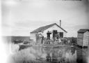
| Date: | 1910 |
|---|---|
| Description: | View across water towards a group of seven men posing on a dock in front of a small hunting shack in the middle of a marsh. Ducks hang on stringers attache... |

| Date: | 1891 |
|---|---|
| Description: | This map shows soft marshland, water channels, solid ground, club boundary and shooting boxes. Big Lake, First Channel, Second Channel, Fout Mile Pond, Mal... |

| Date: | |
|---|---|
| Description: | View across water towards a man wearing a hat and hip waders sitting on a wooden chair partially submerged in the water. He is holding a fishing pole. A ma... |

| Date: | 06 30 1895 |
|---|---|
| Description: | A man is standing in the right foreground near a tall plant, perhaps corn. In the center is a square-shaped pond with high banks. A man is in the backgroun... |

| Date: | 1789 |
|---|---|
| Description: | Map of New York City showing ward boundaries, ferries, streets, roads, swamps, ponds, and rivers. The properties of Lispinard, Byards, Jones, Rutgers, and ... |

| Date: | 1776 |
|---|---|
| Description: | Fairly detailed map of New York City and parts of Long Island. It shows streets, roads, wharves, ferries, ship yards, Fort George and the battery, public b... |

| Date: | 1769 |
|---|---|
| Description: | Map of New Orleans at the start of the French & Indian War, including two inset maps of the Mississippi River Delta and Fort la Balise. It shows streets, r... |

| Date: | 1761 |
|---|---|
| Description: | Map of New Orleans with north oriented towards the upper right corner. It shows the land around the city, the Mississippi River, anchorages, roads leading ... |
If you didn't find the material you searched for, our Library Reference Staff can help.
Call our reference desk at 608-264-6535 or email us at:
