 Filter: Categories of Wisconsin Historical Images
Filter: Subject of Ponds
Filter: Subject of land use, urban
Filter: Categories of Wisconsin Historical Images
Filter: Subject of Ponds
Filter: Subject of land use, urban

| Date: | 1964 |
|---|---|
| Description: | Aerial view of the Milwaukee County Zoo grounds nearing its completion. |

| Date: | 1892 |
|---|---|
| Description: | Bird's-eye view of the Columbian Exposition pavilions from the vantage point of Lake Michigan. Included is an inset of the Union Passenger Station (now Uni... |

| Date: | 1900 |
|---|---|
| Description: | Elevated view of parade turning from Nebraska Street onto Main Street. Women with umbrellas line the sidewalk in the foreground of the image. The Montello ... |

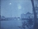
| Date: | 1893 |
|---|---|
| Description: | Cyanotype scenic view of the 1893 Chicago World's Columbian Exposition grounds showing the U.S. Government Building and a bridge over the lagoon. |

| Date: | 1893 |
|---|---|
| Description: | Cyanotype view of the Illinois Building at Chicago's World's Columbian Exposition showing a gondola and motor launch on the lagoon near a bridge. A wing of... |

| Date: | 1893 |
|---|---|
| Description: | A cyanotype view of the Horticulture Building at the World's Columbian Exposition with the dome of the Illinois Building in the background. There is a mot... |

| Date: | 1893 |
|---|---|
| Description: | A cyanotype view of the central basin, Peristyle and Statue of the Republic. There are several boats on the basin. On the right is a large statue of a bu... |
| Date: | 1893 |
|---|---|
| Description: | A cyanotype view across lagoon from shoreline of the U.S. Government Building (right), and the Fisheries building (left). There is a bridge over the lagoon... |
| Date: | 1893 |
|---|---|
| Description: | A cyanotype view of the World's Columbian Exposition grounds from near the North Loop elevated railway station, showing the glass dome of the Horticulture ... |

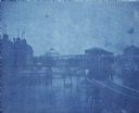
| Date: | 1893 |
|---|---|
| Description: | A cyanotype view of the Agriculture Building (right) and Manufactures and Liberal Arts Building (left) from the bank of the South Canal at the World's Colu... |

| Date: | 1941 |
|---|---|
| Description: | This map shows heavy and light industry, residences, and business districts as well as streets and Mill Pond. The front and back of the map include extensi... |

| Date: | 1789 |
|---|---|
| Description: | Map of New York City showing ward boundaries, ferries, streets, roads, swamps, ponds, and rivers. The properties of Lispinard, Byards, Jones, Rutgers, and ... |

| Date: | 1776 |
|---|---|
| Description: | Fairly detailed map of New York City and parts of Long Island. It shows streets, roads, wharves, ferries, ship yards, Fort George and the battery, public b... |

| Date: | 1769 |
|---|---|
| Description: | Map of New Orleans at the start of the French & Indian War, including two inset maps of the Mississippi River Delta and Fort la Balise. It shows streets, r... |

| Date: | 1761 |
|---|---|
| Description: | Map of New Orleans with north oriented towards the upper right corner. It shows the land around the city, the Mississippi River, anchorages, roads leading ... |
If you didn't find the material you searched for, our Library Reference Staff can help.
Call our reference desk at 608-264-6535 or email us at: