 Filter: Categories of Wisconsin Historical Images
Filter: Subject of Ponds
Filter: Subject of church buildings
Filter: Categories of Wisconsin Historical Images
Filter: Subject of Ponds
Filter: Subject of church buildings

| Date: | 1874 |
|---|---|
| Description: | Bird's-eye map of Chippewa Falls. |

| Date: | 1879 |
|---|---|
| Description: | Bird's-eye view of Viroqua, county seat of Vernon County. |
| Date: | |
|---|---|
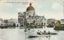
| Description: | St. Josephat Church and School from Kosciuszko Park. The classic style church with dome is across a body of water. Three boats with boaters are out rowing ... |
| Date: | 08 28 1898 |
|---|---|
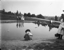
| Description: | Syl playing with toy boats at a small pond at Reservoir Park. Other children and adults are around the pond which is on a hill. In the background below the... |

| Date: | 1928 |
|---|---|
| Description: | View down valley towards the back of the Lutheran Church and cemetery. Houses and barns are in the valley below, and more hills are in the far background. ... |

| Date: | 1789 |
|---|---|
| Description: | Map of New York City showing ward boundaries, ferries, streets, roads, swamps, ponds, and rivers. The properties of Lispinard, Byards, Jones, Rutgers, and ... |

| Date: | 1761 |
|---|---|
| Description: | Map of New Orleans with north oriented towards the upper right corner. It shows the land around the city, the Mississippi River, anchorages, roads leading ... |

| Date: | 1914 |
|---|---|
| Description: | Pg. 44 West Half of Marion Township. Pg. 45 East Half of Marion Township. |
If you didn't find the material you searched for, our Library Reference Staff can help.
Call our reference desk at 608-264-6535 or email us at:

