 Filter: Categories of Wisconsin Historical Images
Filter: Subject of Ponds
Filter: County of Walworth
Filter: Subject of land
Filter: Categories of Wisconsin Historical Images
Filter: Subject of Ponds
Filter: County of Walworth
Filter: Subject of land
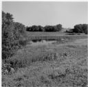
| Date: | 2001 |
|---|---|
| Description: | Landscape view of the pond at the Old Place on the Quinney farm. |

| Date: | 1900 |
|---|---|
| Description: | Pen and pencil on tracing paper. Shows landownership by name, local streets, local businesses, mill pond, creek, and proposed railroad. |
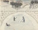
| Date: | 1945 |
|---|---|
| Description: | Three boys play ice hockey on a frozen pond. One boy has fallen and is sitting on the ice. Snow covers the ground, with some grass peeking through. A fence... |

| Date: | 1930 |
|---|---|
| Description: | This map has relief shown pictorially and shows plat of the city, block numbers, land ownership by name, local streets, railroads, mill pond, and part of G... |

| Date: | 1962 |
|---|---|
| Description: | This blue print map shows 5 zoning districts, as well as lot and block numbers and dimensions, public land, streets, and Mill Pond. The zones are: "Single ... |

| Date: | 05 2014 |
|---|---|
| Description: | View across field towards two young cows grazing on a hilly pasture. There is a bur oak in the distance at the bottom of the pasture, and beyond is a pond. |

| Date: | |
|---|---|
| Description: | View of a man driving an automobile down a road, approaching a wooden bridge over a stream next to a pond. Dwellings are on the slope of a hill in the back... |
If you didn't find the material you searched for, our Library Reference Staff can help.
Call our reference desk at 608-264-6535 or email us at: