 Filter: Categories of Wisconsin Historical Images
Filter: Subject of Ponds
Filter: County of Dane
Filter: Year of 1800-1899
Filter: Categories of Wisconsin Historical Images
Filter: Subject of Ponds
Filter: County of Dane
Filter: Year of 1800-1899
| Date: | 1879 |
|---|---|
| Description: | A pond at the Wisconsin State Fish Hatchery (aka Nevin Fish Hatchery, 3911 Fish Hatchery Road) with a sign reading "Brook Trout 3 and 4 years old." Funds f... |

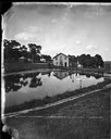
| Date: | 1875 |
|---|---|
| Description: | An artist's depiction of an elevated view of the first State Fish Hatchery (aka Nevin Fish Hatchery, 3911 Fish Hatchery Road). |

| Date: | 1873 |
|---|---|
| Description: | A map of the township of Montrose from the "Atlas of Dane County." |

| Date: | 06 30 1895 |
|---|---|
| Description: | A man is standing in the right foreground near a tall plant, perhaps corn. In the center is a square-shaped pond with high banks. A man is in the backgroun... |
If you didn't find the material you searched for, our Library Reference Staff can help.
Call our reference desk at 608-264-6535 or email us at:
