 Filter: Categories of Wisconsin Historical Images
Filter: Subject of Ponds
Filter: Type of Map or Atlas
Filter: Categories of Wisconsin Historical Images
Filter: Subject of Ponds
Filter: Type of Map or Atlas
| Date: | |
|---|---|
| Description: | This plat map is pen, pencil, and watercolor on paper and shows numbered blocks and lots, local streets, section lines, the public square, Mill pond, and l... |

| Date: | 1959 |
|---|---|
| Description: | This map shows some land ownership, lot and block numbers, additions, fair grounds, streets, and railroads and is indexed. Mullet River and Mill Pond are l... |

| Date: | 1896 |
|---|---|
| Description: | This map shows plat of town, local streets, numbered blocks and lots, mill pond, mills, part of the Red Cedar River, and land and property ownership by nam... |

| Date: | 1937 |
|---|---|
| Description: | This is map 1 from a set of 4 taken from an atlas. The map shows streets, neighborhoods and proposed subdivision. Lake Michigan, Algoma Outer Harbor, the A... |

| Date: | 1891 |
|---|---|
| Description: | This map shows soft marshland, water channels, solid ground, club boundary and shooting boxes. Big Lake, First Channel, Second Channel, Fout Mile Pond, Mal... |

| Date: | 1891 |
|---|---|
| Description: | This map shows soft marshland, water channels, solid ground, club boundary and shooting boxes. Big Lake, First Channel, Second Channel, Fout Mile Pond, Mal... |

| Date: | 1912 |
|---|---|
| Description: | Marinette County, Township 36 N., Range 20 E. |

| Date: | 1912 |
|---|---|
| Description: | Marinette County, Fract. Township 37 N., Ranges 21 and 22 E. |

| Date: | 1900 |
|---|---|
| Description: | This map shows logging roads, railroads with spur lines, trails, rapids, lumber camps, Indian villages, summer resort, lakes, rivers, and ponds. |

| Date: | 1941 |
|---|---|
| Description: | This map shows heavy and light industry, residences, and business districts as well as streets and Mill Pond. The front and back of the map include extensi... |

| Date: | 1910 |
|---|---|
| Description: | This set of manuscript blueprint maps show block and lot numbers, railroads, and some landownership, including lands and buildings of J.S. Owen Lumber Co. ... |
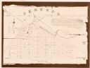
| Date: | 1994 |
|---|---|
| Description: | This cadastral map shows Mill Pond, buildings, some landowners, cemetery, and out-lots. The upper right corner includes a statement about Ceresco. |

| Date: | 02 1777 |
|---|---|
| Description: | Map depicting the campaigns of October and November 1776, in Manhattan, Westchester, and part of New Jersey, published only a few months after the conclusi... |

| Date: | 1789 |
|---|---|
| Description: | Map of New York City showing ward boundaries, ferries, streets, roads, swamps, ponds, and rivers. The properties of Lispinard, Byards, Jones, Rutgers, and ... |

| Date: | 1776 |
|---|---|
| Description: | Fairly detailed map of New York City and parts of Long Island. It shows streets, roads, wharves, ferries, ship yards, Fort George and the battery, public b... |

| Date: | 1769 |
|---|---|
| Description: | Map of New Orleans at the start of the French & Indian War, including two inset maps of the Mississippi River Delta and Fort la Balise. It shows streets, r... |

| Date: | 1761 |
|---|---|
| Description: | Map of New Orleans with north oriented towards the upper right corner. It shows the land around the city, the Mississippi River, anchorages, roads leading ... |

| Date: | 1931 |
|---|---|
| Description: | A plat map of Springfield, Wisconsin. |
If you didn't find the material you searched for, our Library Reference Staff can help.
Call our reference desk at 608-264-6535 or email us at:

