 Filter: Categories of Wisconsin Historical Images
Filter: Subject of Plants
Filter: County of Columbia
Filter: Categories of Wisconsin Historical Images
Filter: Subject of Plants
Filter: County of Columbia
| Date: | 1935 |
|---|---|
| Description: | A view of the Portage Canal. In the immediate foreground is the Fox River, then the lower locks and the canal itself. The Indian Agency House may be seen t... |
| Date: | 1940 |
|---|---|
| Description: | A marker at the site of the former village of Oshaukuta on Highway 51, north of Portage. The marker states: "This tablet marks the site where the village o... |
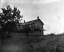
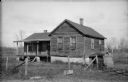
| Date: | 1907 |
|---|---|
| Description: | View up dirt road or track towards a two-story L-shaped frame house with a fence along the front. The right end of the house has a roof suspended over the ... |

| Date: | |
|---|---|
| Description: | Steamboat near a cliff on the Wisconsin River, presumably in the Wisconsin Dells. |

| Date: | |
|---|---|
| Description: | Statue of St. Francis is in a field beyond a lawn and small vine-covered building on the right. |
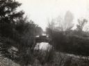
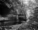
| Date: | |
|---|---|
| Description: | Rustic log footbridge over a creek in the woods. |
| Date: | 1910 |
|---|---|
| Description: | View from bank of the Wisconsin River of the Jaws of the Dells in winter. Snow is on the ground and ice lines the shoreline. |
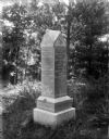
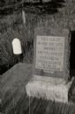
| Date: | 1910 |
|---|---|
| Description: | The Staudenmayer grave marker set amid the lush vegetation of Durwards Glen. |
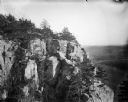
| Date: | 1910 |
|---|---|
| Description: | View of the face of the bluff at Gibraltar Rock, with farmland and other bluffs far below in the distance. |
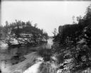
| Date: | 1910 |
|---|---|
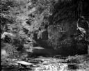
| Description: | A view of a ravine showing rock strata and a stream. |
| Date: | 1909 |
|---|---|
| Description: | A view of the "Glen of the Calydon" showing a stream and rock formations. |
| Date: | |
|---|---|
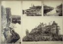
| Description: | A composite of photographs from various places in the Wisconsin Dells. The picture along the left is of a rock formation high above two women in a canoe in... |
| Date: | |
|---|---|
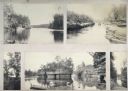
| Description: | A composite of five photographs taken in and around the Wisconsin Dells, including a photograph of an excursion boat on the river, a canoe beached on the s... |

| Date: | 1894 |
|---|---|
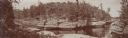
| Description: | Panoramic view from shoreline of the Wisconsin River in the Wisconsin Dells as seen from the "Old Dell House." A canoe is visible on the shore on the far r... |

| Date: | |
|---|---|
| Description: | Elevated panoramic view of the Wisconsin River shoreline in the Wisconsin Dells. There is an excursion boat, The Dell Queen, visible in the lower le... |

| Date: | 1894 |
|---|---|
| Description: | Panoramic view from shoreline of the Wisconsin River in the Wisconsin Dells. A sandy beach area is on the right, and rock formations are on both sides of t... |

| Date: | 1896 |
|---|---|
| Description: | Elevated panoramic view of a section of the Wisconsin Dells and the Wisconsin River visible from the "Sliding Rock." In the lower left hand corner the word... |
| Date: | 1900 |
|---|---|
| Description: | Elevated panoramic view of the narrows of the Wisconsin River in the Wisconsin Dells. On the far left on a label are the words "THE NARROWS, DELLS OF THE W... |

| Date: | 1907 |
|---|---|
| Description: | A well-dressed man stands on barren, sandy soil identified as an Indian village site near Okee. Near him the soil is stained darker than the surrounding ar... |
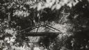
| Date: | 1924 |
|---|---|
| Description: | The old toll house. The house is surrounded by a sagging wire fence, and there are two pumps in the overgrown yard. |
If you didn't find the material you searched for, our Library Reference Staff can help.
Call our reference desk at 608-264-6535 or email us at: