 Filter: Categories of Wisconsin Historical Images
Filter: Subject of Pioneers
Filter: Year of 1900-1999
Filter: Categories of Wisconsin Historical Images
Filter: Subject of Pioneers
Filter: Year of 1900-1999
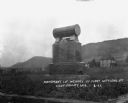
| Date: | 1922 |
|---|---|
| Description: | Monument dedicated to the first settlers of Coon Valley. The monument is in Norwegian. There is a cemetery in the distance. |

| Date: | 1937 |
|---|---|
| Description: | Label submitted to the state of Wisconsin for trademark registration. "Pioneer Beer, G. Weber Brewing Co." Under this in the center is a leaf with the lett... |

| Date: | 1933 |
|---|---|
| Description: | Label submitted to the State of Wisconsin for trademark registration. "Pioneer Lager Beer, Bottled by De Pere Brewing Corp." The label is divided into tria... |
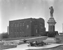
| Date: | 1925 |
|---|---|
| Description: | Outside the Swingli House, near a memorial for the first New Glarus settlers. |

| Date: | 12 25 1942 |
|---|---|
| Description: | This hand-drawn map shows the highways and features in the Rock Lake-Lake Mills area in the towns of Aztalan and Lake Mills, Jefferson County, Wisconsin. T... |

| Date: | 05 1995 |
|---|---|
| Description: | "Pioneer reenactors set up their tents on the Rock River in Mayville." |

| Date: | 09 07 1997 |
|---|---|
| Description: | "Pioneer Days is celebrated at Firemen's Park. Civil War reenactors, in period garb, put on a show of battlefield conditions." |
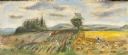
| Date: | 1948 |
|---|---|
| Description: | Prior to the 1948 State Fair, artist Robert Hodgell traveled Wisconsin to study its many landscapes. He then produced a series of study sketches outlining ... |
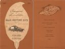
| Date: | 04 22 1952 |
|---|---|
| Description: | Menu from the Inaugural Luncheon of the Half-Century Club of the National Association of Tobacco Distributors, with a pioneer driving a team of horses pull... |

| Date: | 1940 |
|---|---|
| Description: | This map of Aztalan is pencil and ink on paper. The map shows streets, local businesses, churches, houses, and the Crawfish River. The map reads: "Informat... |

| Date: | 1937 |
|---|---|
| Description: | Pictorial map showing historical events and locations within the state of Wisconsin, as well as waterways and counties. Original caption on the bottom marg... |

| Date: | 1942 |
|---|---|
| Description: | This pictorial bird's-eye-view map shows the United States of America with parts of Canada and Mexico. Landscape, trade, industry, points of interest, peop... |

| Date: | 1946 |
|---|---|
| Description: | This map shows scenes from America's history with names of historical events superimposed on a map of the United States. |
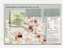
| Date: | 1998 |
|---|---|
| Description: | This map shows the number of Welsh-born heads of households around 1870. A small inset map in the lower left corner shows Welsh land ownership in the heart... |

| Date: | 1929 |
|---|---|
| Description: | This map with north oriented to the upper left shows military forts, Indian villages, settler's houses with surnames, trading houses, lodges and encampment... |
| Date: | 08 10 1954 |
|---|---|
| Description: | At the Sun Prairie Early Settlers' picnic at Angell Park, the oldest settler present was Julia McElroy, 89, pictured with her son, George McElroy. |

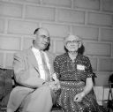
| Date: | 09 06 1954 |
|---|---|
| Description: | Entering the grounds of the Ringling Brothers-Barnum and Bailey Circus is 96 year-old Nellie Kedzie Jones, an educational pioneer and Home Economics Extens... |

| Date: | 09 06 1954 |
|---|---|
| Description: | Attending the Ringling Brother-Barnum and Bailey Circus is 96 year-old Nellie Kedzie Jones, an educational pioneer and Home Economics Extension leader at t... |

| Date: | 09 06 1954 |
|---|---|
| Description: | Talking to the ringmaster at a Ringling Brothers-Barnum and Bailey Circus show is 96 year-old Nellie Kedzie Jones, an educational pioneer and Home Economic... |

| Date: | 09 06 1954 |
|---|---|
| Description: | Intently watching the performance at the Ringling Brother-Barnum and Bailey Circus is 96 year-old Nellie Kedzie Jones, an educational pioneer and Home Econ... |
If you didn't find the material you searched for, our Library Reference Staff can help.
Call our reference desk at 608-264-6535 or email us at: