 Filter: Categories of Wisconsin Historical Images
Filter: Subject of Piers
Filter: Year of 1800-1899
Filter: County of Manitowoc
Filter: Categories of Wisconsin Historical Images
Filter: Subject of Piers
Filter: Year of 1800-1899
Filter: County of Manitowoc

| Date: | 1879 |
|---|---|
| Description: | Bird's-eye map of Two Rivers. |
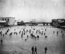
| Date: | 1888 |
|---|---|
| Description: | Elevated view of a winter scene with a large group of people skating on the frozen Manitowoc River between the 8th and 10th Street bridges. A dog trots acr... |

| Date: | 09 1853 |
|---|---|
| Description: | This map shows streets, docks, warehouses, and piers near the harbor. The Manitowoc River and Lake Michigan are labeled. Depths are indicated by soundings ... |

| Date: | 1854 |
|---|---|
| Description: | This map shows streets, docks, warehouses, and piers near the harbor. Relief is shown by hachures and depths are shown by soundings and isolines. Lake Mich... |

| Date: | 1856 |
|---|---|
| Description: | This map shows streets, piers, and wharves. Lake Michigan, the Manitowoc River, and select buildings are labeled. Relief is shown by hachures and sounding... |

| Date: | 1865 |
|---|---|
| Description: | This map shows the river shore and piers. Lake Michigan is labeled. Depths are shown by soundings and isolines. The bottom margin includes notes on soundi... |

| Date: | 1874 |
|---|---|
| Description: | This map shows piers, streets, the Manitowoc River and shore lines of 1856, 1869, 1873 and 1874. The top margin reads; "Soundings taken 1974." Written in i... |
If you didn't find the material you searched for, our Library Reference Staff can help.
Call our reference desk at 608-264-6535 or email us at: