 Filter: Categories of Wisconsin Historical Images
Filter: Subject of Piers
Filter: Type of Map or Atlas
Filter: Year of 1800-1899
Filter: Categories of Wisconsin Historical Images
Filter: Subject of Piers
Filter: Type of Map or Atlas
Filter: Year of 1800-1899

| Date: | 1886 |
|---|---|
| Description: | Bird's-eye view of Ashland, on the shores of Lake Superior, with insets of The Apostle Islands Chequamagon Bay & Ashland, and Distances from Ashland. |

| Date: | 1856 |
|---|---|
| Description: | View looking west from Lake Michigan with several steam ships and sailing vessels in harbor. There is a lighthouse to left of center, along shoreline. |

| Date: | 1886 |
|---|---|
| Description: | Bird's-eye view of Bayfield, county seat of Bayfield County. On the lower left side is an inset for Bayfield and the Apostle Islands. |

| Date: | 1885 |
|---|---|
| Description: | Bird's-eye view of Sheboygan, with inset of J.J. Volrath Manufacturing Company. |

| Date: | 1883 |
|---|---|
| Description: | Bird's-eye map of Superior, county seat of Douglas County, on the shores of Lake Superior, with insets of points of interest. |

| Date: | 1892 |
|---|---|
| Description: | Bird's-eye view of Chicago, with ships in the Lake Michigan harbor. |

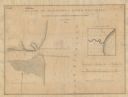
| Date: | 1836 |
|---|---|
| Description: | A detailed map of the mouth of the Kewaunee River, showing the geological composition of the Lake Michigan shoreline and the various water depths in the ar... |
| Date: | 1836 |
|---|---|
| Description: | A hand-drawn map of the mouth of the Manitowoc River at Lake Michigan, showing depth of the water by contour lines. The included inset map shows the region... |

| Date: | 1861 |
|---|---|
| Description: | This map shows lot and block numbers, piers, streets, monuments, and township section corners. Included is a note on the width of avenues, piers, slips, al... |

| Date: | 07 19 1854 |
|---|---|
| Description: | This hand-colored map shows the North and South Pier, the North Pier Bridge, the present Channel, and the Channel to be dredged. Lake Michigan and a light ... |

| Date: | 09 1853 |
|---|---|
| Description: | This map shows streets, docks, warehouses, and piers near the harbor. The Manitowoc River and Lake Michigan are labeled. Depths are indicated by soundings ... |

| Date: | 1854 |
|---|---|
| Description: | This map shows streets, docks, warehouses, and piers near the harbor. Relief is shown by hachures and depths are shown by soundings and isolines. Lake Mich... |

| Date: | 1856 |
|---|---|
| Description: | This map shows streets, piers, and wharves. Lake Michigan, the Manitowoc River, and select buildings are labeled. Relief is shown by hachures and sounding... |

| Date: | 1865 |
|---|---|
| Description: | This map shows the river shore and piers. Lake Michigan is labeled. Depths are shown by soundings and isolines. The bottom margin includes notes on soundi... |

| Date: | 1874 |
|---|---|
| Description: | This map shows piers, streets, the Manitowoc River and shore lines of 1856, 1869, 1873 and 1874. The top margin reads; "Soundings taken 1974." Written in i... |

| Date: | 10 1853 |
|---|---|
| Description: | This map shows warehouses and proposed extensions of piers. "Note: The soundings are in feet and tenths." The upper left margin reads: "Senate Ex. Doc. No.... |

| Date: | 10 1853 |
|---|---|
| Description: | This map shows warehouses and proposed extensions of piers. Also included are notes on soundings and the proposed extensions. The upper right margin reads:... |
If you didn't find the material you searched for, our Library Reference Staff can help.
Call our reference desk at 608-264-6535 or email us at: