 Filter: Categories of Wisconsin Historical Images
Filter: Subject of Pastures
Filter: Subject of rivers
Filter: Categories of Wisconsin Historical Images
Filter: Subject of Pastures
Filter: Subject of rivers

| Date: | 1744 |
|---|---|
| Description: | A map of a plan of 16,500 acres of land. |
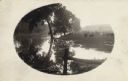
| Date: | |
|---|---|
| Description: | River, with fence in foreground, reflecting trees and sunlight. On the right is a field with cows, a man near a fence, and a small dog. |
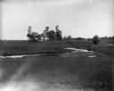
| Date: | |
|---|---|
| Description: | The Richardson Farm stands at the far edge of a farm field with a creek running through it and animals grazing. The farmhouse is white and surrounded by tr... |
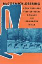
| Date: | 1938 |
|---|---|
| Description: | Cover of a McCormick-Deering brochure featuring corn shellers, feed grinders, hammer and roughage mills. |

| Date: | 1899 |
|---|---|
| Description: | Overhead map of the Stanley McCormick's Riven Rock estate in El Montecito, Santa Barbara, California. The map shows the placement of dwellings and fields, ... |
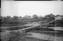
| Date: | 1918 |
|---|---|
| Description: | View looking down low hill towards a narrow footbridge which crosses a small river to a village composed of wooden buildings with wooden fences. On the rig... |

| Date: | |
|---|---|
| Description: | Colorized, elevated view of the Pecatonica River with several of its many curves. Cows are grazing in the pasture in the foreground. The landscape is dotte... |

| Date: | |
|---|---|
| Description: | Landscape view down hill towards valley, with a railroad bridge over a river. Pasture lands are in the distance. |

| Date: | 1762 |
|---|---|
| Description: | Map of Virginia and parts of Maryland. It shows borders, boundary lines, Native American tribes and land, towns, forts, roads, mountains, waterfalls, bays,... |
If you didn't find the material you searched for, our Library Reference Staff can help.
Call our reference desk at 608-264-6535 or email us at: