 Filter: Categories of Wisconsin Historical Images
Filter: Subject of Pastures
Filter: Subject of architecture
Filter: Subject of landscape
Filter: Categories of Wisconsin Historical Images
Filter: Subject of Pastures
Filter: Subject of architecture
Filter: Subject of landscape

| Date: | |
|---|---|
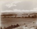
| Description: | Elevated view of the town with hills in the distance. In the foreground are cattle inside a fence near a cemetery with a windmill. The town is behind furth... |
| Date: | 1912 |
|---|---|
| Description: | Pasture and trees below the southeast side of Taliesin I. |
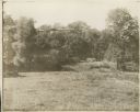
| Date: | 1912 |
|---|---|
| Description: | Pasture and trees below the southeast side of Taliesin I. Two cows are in the pasture. |

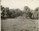
| Date: | 1897 |
|---|---|
| Description: | Topographical map of Stanley McCormick's Riven Rock estate in El Montecito, Santa Barbara County, California. The map is identified as a map of a survey co... |
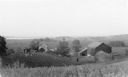
| Date: | 1935 |
|---|---|
| Description: | Elevated view from hill of chickens ranging near their coop behind a farmhouse and outbuildings on a tidy farm. There is a large barn on the right with two... |
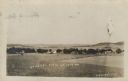
| Date: | 1911 |
|---|---|
| Description: | Elevated view across fields towards a small town. Caption reads: "General View of Leon, Wis." |
| Date: | 1892 |
|---|---|
| Description: | An elevated view of a gently rolling landscape with cows grazing in the middle distance. At right is a farmhouse and outbuildings. Young trees have been pl... |
If you didn't find the material you searched for, our Library Reference Staff can help.
Call our reference desk at 608-264-6535 or email us at: