 Filter: Categories of Wisconsin Historical Images
Filter: Subject of Parks
Filter: Year of 2000-Present
Filter: Subject of transportation
Filter: Year of 2000-2009
Filter: Categories of Wisconsin Historical Images
Filter: Subject of Parks
Filter: Year of 2000-Present
Filter: Subject of transportation
Filter: Year of 2000-2009

| Date: | 2007 |
|---|---|
| Description: | This map of Cedarbug is a bird's-eye map with 8 inset views and an index. The map is a print out of the original map dated 1892 held at the Cedarburg Cultu... |

| Date: | 2004 |
|---|---|
| Description: | View from across street of a man holding Bush-Cheney '04 sign along intersection. A man next to him holds an illegible sign. |
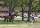
| Date: | 2008 |
|---|---|
| Description: | A female bike rider looks over at police officer riding a horse at Riverside Park. |
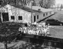
| Date: | 05 2000 |
|---|---|
| Description: | Group of students at Theresa Fireman's Park for Arbor Day activities. |

| Date: | 2008 |
|---|---|
| Description: | This double sided map shows roads, railroads, biking trails, civil townships, parks, wildlife refuges, town halls, and hospitals. The region map covers par... |

| Date: | 2000 |
|---|---|
| Description: | This map shows Wisconsin Public Service Corporation property, special regulation areas, public boat landings, roads, parks, and other recreation areas. Ins... |

| Date: | 2004 |
|---|---|
| Description: | This map shows ATMs, houses of worship, hotels, parking ramps, public parking, union cab stands, bus stops, business district, parks and public areas, gove... |

| Date: | 2000 |
|---|---|
| Description: | This map shows the industrial area along the Menominee River and canals. Industrial buildings are shown in orange and labeled in red. Other areas are shown... |
If you didn't find the material you searched for, our Library Reference Staff can help.
Call our reference desk at 608-264-6535 or email us at: