Filter: Categories of Wisconsin Historical Images
Filter: Subject of Parks
Filter: Year of 1900-1999
Filter: Categories of Wisconsin Historical Images
Filter: Subject of Parks
Filter: Year of 1900-1999

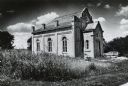
| Date: | 06 1980 |
|---|---|
| Description: | Identified only as the intersection of Flowage Road and State Highway 173 in Juneau County, this image probably shows the entrance to the Meadow Valley Flo... |
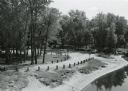
| Date: | 09 20 1972 |
|---|---|
| Description: | Wayside #8 near Necedah in rural Adams County. |
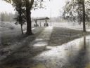
| Date: | 09 30 1970 |
|---|---|
| Description: | Point Bluff Wayside as viewed from the highway bridge above. |

| Date: | 09 11 1955 |
|---|---|
| Description: | A group of Republicans attending a picnic in Hoyt Park sponsored by the Dane County GOP, the Young Republicans and the Dane County Women's Republican Club. |
| Date: | 1900 |
|---|---|
| Description: | A drawing of Levee Park in La Crosse, with the Mississippi River in the foreground, and La Crosse in the background. |

| Date: | 04 14 1974 |
|---|---|
| Description: | View of the Tenney Park bridge casting a reflection in the water of the lagoon. |
| Date: | 1974 |
|---|---|
| Description: | The "Gates of Heaven Synagogue" at James Madison Park. |

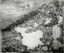
| Date: | 1904 |
|---|---|
| Description: | This map shows a plat of the east part of the city, numbered blocks and lots, some landownership, local streets, roads, railroads, wards by number, parks, ... |
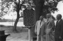
| Date: | 06 26 1955 |
|---|---|
| Description: | Arthur Melster, President of Cambridge Foundation; K.K. Amundson. M.D. of Cambridge; and W.T. Webb of Evinrude Motors, look at the Lake Ripley Ole Evinrude... |

| Date: | 07 05 1975 |
|---|---|
| Description: | The Tenney Park Bridge over the Yahara River. |
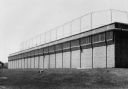
| Date: | 10 31 1976 |
|---|---|
| Description: | Exterior view of a tennis court situated on top of the Madison Water Utility pumping station at Reynolds Park, which is on Livingston Street between East D... |
| Date: | 1914 |
|---|---|
| Description: | View of people at Silurian Spring, located in Waukesha Springs Park. Caption reads: "Silurian Spring, Waukesha, Wis." |

| Date: | 1905 |
|---|---|
| Description: | View of the Bethesda Spring. Caption reads: "Bethesda Spring, Waukesha, Wis." |
| Date: | 1910 |
|---|---|
| Description: | View of Bethesda Spring. Caption reads: "Bethesda Spring, Waukesha, Wis." |

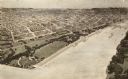
| Date: | 1904 |
|---|---|
| Description: | This map shows a plat of the west part of the city, numbered blocks and lots, some landownership, local streets, roads, railroads, wards by number, parks, ... |
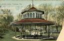
| Date: | 1920 |
|---|---|
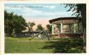
| Description: | View of Riverview Park, with gazebo and slide in foreground. Caption reads: "Riverview Park, Watertown, Wis." |
| Date: | 1904 |
|---|---|
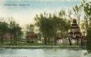
| Description: | View across water towards Brower Park near Houghton Point. |
| Date: | 1950 |
|---|---|
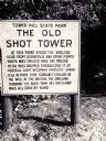
| Description: | The sign marking the location of the shot tower smelter. |
| Date: | 1910 |
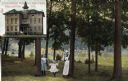
|---|---|
| Description: | Park view featuring two children and their nurse or nanny in the foreground and an inset of the hospital in the upper left corner. Caption reads: "Stoughto... |
If you didn't find the material you searched for, our Library Reference Staff can help.
Call our reference desk at 608-264-6535 or email us at: