 Filter: Categories of Wisconsin Historical Images
Filter: Subject of Parks
Filter: Subject of tourism
Filter: Categories of Wisconsin Historical Images
Filter: Subject of Parks
Filter: Subject of tourism
| Date: | |
|---|---|
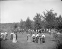
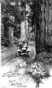
| Description: | Slightly elevated view of Kilbourn railroad park. There is a group of tourists walking down to Dells Landing. |
| Date: | 1925 |
|---|---|
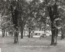
| Description: | The tourist park in Black Earth. Typically such facilities were free for motorists. |

| Date: | 1925 |
|---|---|
| Description: | The Olin Park tourist campground on the shore of Lake Monona in Madison. |
| Date: | |
|---|---|
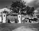
| Description: | Entrance to Enchanted Forest and Prehistoric Land. |
| Date: | |
|---|---|
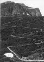
| Description: | Elevated view of a donkey train going up a zig-zag trail along the mountainside in Glacier National Park. |
| Date: | |
|---|---|
| Description: | View toward a line of tourist cars driving through a narrow road in Rainier National Park. There are redwood trees on either side of the path. Caption read... |
| Date: | 04 13 1925 |
|---|---|
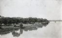
| Description: | Elevated view over the Illinois River towards Allen Park, a free tourist camp. Tents are set up along the bank of the river, and a bridge spans the water i... |
| Date: | 1925 |
|---|---|
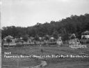
| Description: | View of two-seat lawn swings amid trees on a lawn. Cabins are along a hill in the background. There is an information center on the far left. |
| Date: | 1927 |
|---|---|
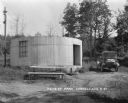
| Description: | A cylinder-shaped cement building with an open door in a rural area. In front of the building is a picnic table, and on the right an automobile is parked n... |

| Date: | 1941 |
|---|---|
| Description: | A map of the area south of Ripon and Sheboygan and east of Waterloo and Janesville, showing the route of the Chicago, North Shore and Milwaukee Railroad in... |

| Date: | 1970 |
|---|---|
| Description: | A map of parks of Kewaunee County, Wisconsin, showing the fishing spots, lakes and parks in the area, it also provides a location map of the area. On the ... |

| Date: | 1990 |
|---|---|
| Description: | A tourist map of Lafayette County, Wisconsin, that shows the locations of motels, camping, municipal parks, cheese factory tours, waysides, and golf course... |

| Date: | 1976 |
|---|---|
| Description: | A street map of Milwaukee County, Wisconsin that identifies the location of schools, hospitals, parks, beaches, streets, freeways, both planned or under co... |

| Date: | 1930 |
|---|---|
| Description: | "Issued by Door County Chamber of Commerce." Shows federal system highways, state highways, county trunk highways, country roads, and parks. Includes direc... |

| Date: | 1940 |
|---|---|
| Description: | Shows Milwaukee and Waukesha counties, and parts of Dodge, Washington, Ozaukee, Jefferson, Walworth, and Racine counties. Includes indexes of "Cities, Town... |

| Date: | 1969 |
|---|---|
| Description: | Map showing St. Croix Falls and Taylors Falls, Minnesota. The map was produced by the St. Croix Falls Chamber of Commerce and Taylor Falls Commercial Club.... |

| Date: | 1959 |
|---|---|
| Description: | This map of Lake Geneva has relief shown by contours and water depths shown by isolines. The map includes an index of schools, churches, public services, i... |

| Date: | 1930 |
|---|---|
| Description: | This map features a legend of highways, railroads, parks, and service stations. The cover and inside of the map features pictures of attractions in Madison... |

| Date: | 1956 |
|---|---|
| Description: | Intended for tourists, this brochure features a map of Milwaukee's central business district as well as general information about parking, beaches and othe... |

| Date: | 1960 |
|---|---|
| Description: | View across water towards a man, woman, and two children standing on the rock ledge at Cave Point. Lake Michigan is on the right. |
If you didn't find the material you searched for, our Library Reference Staff can help.
Call our reference desk at 608-264-6535 or email us at: