 Filter: Categories of Wisconsin Historical Images
Filter: Subject of Parks
Filter: Subject of roads
Filter: Categories of Wisconsin Historical Images
Filter: Subject of Parks
Filter: Subject of roads
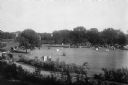
| Date: | 1908 |
|---|---|
| Description: | Elevated view of Vilas Park, filled with groups of people on the lawn, and horse-drawn carriages on the drive. |
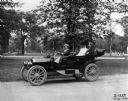
| Date: | 07 14 1910 |
|---|---|
| Description: | Woman and two passengers driving an International J-30 passenger car with its top down through a city park. Also known as the IHC 30, the J-30 was produced... |

| Date: | 1882 |
|---|---|
| Description: | Bird's-eye views of various sections of Milwaukee. |

| Date: | 1882 |
|---|---|
| Description: | Bird's-eye map of Lake Geneva, looking southwest, with insets of points of interest. |

| Date: | 05 18 1934 |
|---|---|
| Description: | Elevated view of East Washington Avenue taken from an upper level of the Wisconsin State Capitol. Shows the First National Bank Building, American Exchange... |

| Date: | 1927 |
|---|---|
| Description: | Color map, hand-drawn with comic figures engaged in various activities throughout map. Bordered by the river on the left and Lake Michigan on the right, in... |
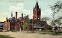
| Date: | 1908 |
|---|---|
| Description: | Union Depot with clock tower. The railroad station with clock tower is behind a park. Horse-drawn vehicles are near the entrance. Caption reads: "Union Dep... |
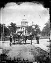
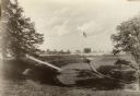
| Date: | 1876 |
|---|---|
| Description: | Issued as a stereograph on green mount entitled "The Artist." Two men stand by a wagon on which is written "A.L. Dahl Landscape Photographer." The flag on... |
| Date: | |
|---|---|
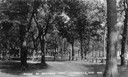
| Description: | Park with tree-lined lane. Caption reads: "Scene in Riverside Park". |
| Date: | |
|---|---|
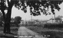
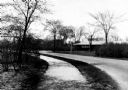
| Description: | Caption reads: "View from the park". View down dirt road, with a large deciduous tree on the left side of the road, and a cornfield on the right. In the di... |
| Date: | |
|---|---|
| Description: | View down a road in the park, leading to a river and a bridge. |
| Date: | 1954 |
|---|---|
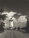
| Description: | View down road towards the Fond du Lac lighthouse, built in 1933. There are cumulus clouds in the sky, and pine trees are lining the shore. |
| Date: | 1935 |
|---|---|
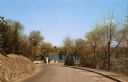
| Description: | View of Kohler Ravine Park. In the right foreground is a small bridge, and on the right is a set of wide, concrete steps leading from the road down the hil... |

| Date: | 06 1980 |
|---|---|
| Description: | Identified only as the intersection of Flowage Road and State Highway 173 in Juneau County, this image probably shows the entrance to the Meadow Valley Flo... |

| Date: | 1904 |
|---|---|
| Description: | This map shows a plat of the east part of the city, numbered blocks and lots, some landownership, local streets, roads, railroads, wards by number, parks, ... |

| Date: | 1904 |
|---|---|
| Description: | This map shows a plat of the west part of the city, numbered blocks and lots, some landownership, local streets, roads, railroads, wards by number, parks, ... |

| Date: | 1920 |
|---|---|
| Description: | Elevated view of Island Park, from Washington Park Drive, looking north from the west end of Kinzie Avenue bridge. |

| Date: | 1905 |
|---|---|
| Description: | Horlick Park, or Island Park, showing the Kinzie Avenue bridge. |
| Date: | 1920 |
|---|---|
| Description: | Island Park, looking south from the east end of Kinzie Avenue bridge. |
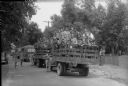
| Date: | 08 02 1944 |
|---|---|
| Description: | Arrival of two truckloads of Truax cadets at Warner Beach. |
If you didn't find the material you searched for, our Library Reference Staff can help.
Call our reference desk at 608-264-6535 or email us at: