 Filter: Categories of Wisconsin Historical Images
Filter: Subject of Parks
Filter: Subject of municipal services
Filter: Categories of Wisconsin Historical Images
Filter: Subject of Parks
Filter: Subject of municipal services

| Date: | 10 25 1957 |
|---|---|
| Description: | Six officials pose for a group portrait at the dedication of a playground structure made of concrete in the shape of a castle; it is sponsored by the Jayce... |

| Date: | 1944 |
|---|---|
| Description: | Shows roads, railroads, schools, dairy plants, seaplane bases, wayside parks, and commercial/municipal fields. "Marathon Forms Map Service, Wisconsin repre... |
| Date: | 1916 |
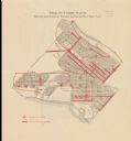
|---|---|
| Description: | Shows streetlights, streets improvements, and sewer districts in red. Points of interest are labelled. Map reads: "Map of Tenth Ward Showing Improvements S... |

| Date: | 1894 |
|---|---|
| Description: | This map shows lot and block numbers, railroads, street car tracks, sewers, water mains, gas mains, paved streets, land owned by the Land & River Improveme... |

| Date: | 1920 |
|---|---|
| Description: | This map shows a plat of the area, numbered blocks and lots, local streets, roads, parks, Nakoma Country Club golf course, and landscaping. The map is orie... |

| Date: | 1892 |
|---|---|
| Description: | This map shows water pipes, hydrants, stop cocks, check valves, fire cysterns, and manholes. Also shown are block numbers, streets, railroads, parks, cemet... |

| Date: | 03 1964 |
|---|---|
| Description: | This map shows lot and block numbers, some landownership, disposal plant and pumping station, streets, parks, and vacated land. Lake Delton and streets are... |

| Date: | 1894 |
|---|---|
| Description: | This map shows sewers, intercepting sewers, manholes, block numbers, streets, railroads, parks, cemeteries, and Lake Michigan. The right margin reads: "Tot... |

| Date: | 1940 |
|---|---|
| Description: | This map hows block and lot numbers, water mains, roads, parks, the Sheboygan River and some landownership. |
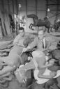
| Date: | 02 27 1958 |
|---|---|
| Description: | Horses from the Vilas Park merry-go-round are being checked before returning to summer use by Angelo Traino (left), a city parks department employee, and J... |
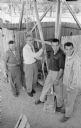
| Date: | 06 21 1958 |
|---|---|
| Description: | Madison Park Superintendent James G. Marshall throwing the switch to turn on the new Vilas Park merry-go-round. Show (L-R) with Marshall are park crew memb... |
If you didn't find the material you searched for, our Library Reference Staff can help.
Call our reference desk at 608-264-6535 or email us at: