 Filter: Categories of Wisconsin Historical Images
Filter: Subject of Parks
Filter: Subject of mounds
Filter: Categories of Wisconsin Historical Images
Filter: Subject of Parks
Filter: Subject of mounds
| Date: | |
|---|---|
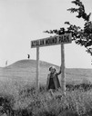
| Description: | Little girl under the "Aztalan Mound Park" sign, in a field. Another person stands in the background on one of the mounds. |
| Date: | |
|---|---|
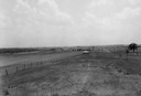
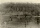
| Description: | View of Aztalan State Park site when it was called Aztalan Mound Park. |
| Date: | |
|---|---|
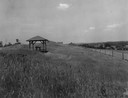
| Description: | Pavilion in the park is on left, with a fence along the right. |
| Date: | 1935 |
|---|---|
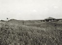
| Description: | View of the site when it was known as Aztalan Mound Park or Aztalan Mounds, near Lake Mills. There is a pavilion in the right background. |

| Date: | 06 1973 |
|---|---|
| Description: | Fifth-graders from Mayville Public School celebrate the end of the school year by running down the earthen mounds at Aztalan State Park. Teachers on the tr... |

| Date: | 10 07 1914 |
|---|---|
| Description: | Sara (Mrs. Joseph) Mallon (Menominee) of Milwaukee, wearing a sash stands between two American flags behind a memorial that reads, "Indian Mounds: One of s... |
| Date: | |
|---|---|
| Description: | Elevated view of Man Mound outlined in chalk looking south. A road bisects the legs of the effigy mound. A small outbuilding can be seen at left in the for... |
| Date: | 12 28 1906 |
|---|---|
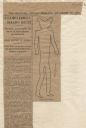
| Description: | Newspaper article about the purchase of land for a park related to Man Mound in Sauk County accompanied by a line drawing of the mound. Article clipped fro... |

| Date: | 1924 |
|---|---|
| Description: | This pictorial map focuses on the Madison Isthmus, Lake Mendota, Lake Monona, Lake Wingra, and shows points of historical interest, buildings, parks, and I... |

| Date: | 10 1911 |
|---|---|
| Description: | This map shows lot numbers, building lines, roads, trees, and Indian mounds. Relief is shown by contours. Includes manuscript annotations marking parks. |

| Date: | 1919 |
|---|---|
| Description: | Narrow red lines show principal secondary highways. Green circles shows points of historical interest. Green triangles show Indian mounds and Indian villag... |
| Date: | |
|---|---|
| Description: | A sketch of effigy mounds at Myrick Park. There is some scribbled-out writing at the top of the page. |

| Date: | |
|---|---|
| Description: | View of burial mounds in a park on the edge of a lake. Caption reads: "Indian Burial Grounds in Wakanda Park, Menomonie, Wis." |

| Date: | 05 26 1906 |
|---|---|
| Description: | The Wisconsin Archeological Society attending the unveiling of the Cutler Indian mound marker at Cutler Park. Mrs. William H. Anderson, President (?) of th... |
If you didn't find the material you searched for, our Library Reference Staff can help.
Call our reference desk at 608-264-6535 or email us at: