 Filter: Categories of Wisconsin Historical Images
Filter: Subject of Parks
Filter: Subject of fishing
Filter: Categories of Wisconsin Historical Images
Filter: Subject of Parks
Filter: Subject of fishing

| Date: | 08 02 1963 |
|---|---|
| Description: | Contestant baits her hook in Washington Park at the annual Milwaukee county park commission's fishing rodeo. |

| Date: | |
|---|---|
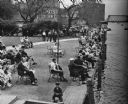
| Description: | A scenic view down sidewalk towards Lake Mendota. People are standing and looking out towards Maple Bluff in the distance. Caption reads: "Scene from Tenne... |

| Date: | 1928 |
|---|---|
| Description: | Children fishing and playing in the water at Vilas Park. |

| Date: | 09 10 1948 |
|---|---|
| Description: | David Bickel, 414 Clemons Avenue, fishing on the shore of Tenney Park lagoon. |

| Date: | 1930 |
|---|---|
| Description: | Pictorial map of Glacier National Park, Montana and Waterton Lakes National Park, Alberta. Illustrated by Joe Scheurle, it depicts white people, American ... |

| Date: | 1930 |
|---|---|
| Description: | The back of the pictorial map titled Recreational Map of Glacier National Park, Montana: Waterton Lakes National Park, Alberta. 14 panels of text and photo... |

| Date: | 07 17 1953 |
|---|---|
| Description: | Mrs. Alvina Niebuhr is shown holding the "winning" contribution can in the campaign to finance the purchase of a northern pike spawning and rearing area in... |
| Date: | 1936 |
|---|---|
| Description: | Elevated view of people in a park along the shoreline waiting for the White Bass run. |

| Date: | 1926 |
|---|---|
| Description: | A brochure with a map of Interstate Park on the Dalles of the Saint Croix River, showing locations of the north and south camp grounds, the fish hatcheries... |

| Date: | 1970 |
|---|---|
| Description: | A map of parks of Kewaunee County, Wisconsin, showing the fishing spots, lakes and parks in the area, it also provides a location map of the area. On the ... |
| Date: | 1926 |
|---|---|
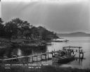
| Description: | Lake Wisconsin at Summerville Park. Boathouses, docks and fishing boats are along the shoreline. |
| Date: | 1927 |
|---|---|
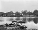
| Description: | View from shoreline of a pair of men fishing in a lake. Another rowboat is tied at a pier in the foreground. On the far shoreline are cottages and trees. |
| Date: | |
|---|---|
| Description: | We've at least been able to conserve something if it's only the idea of conserving for conservation's sake But the community interests ought to come fir... |

| Date: | 08 22 1959 |
|---|---|
| Description: | Gary McKenna holds a fishing rod and small fish in one hand and a flashlight in the other. The boy won the flashlight as a prize for being the first to cat... |

| Date: | 08 03 1953 |
|---|---|
| Description: | Fishermen ranging in age from seven years to over seventy cast from the breakwater at Tenney Park. |

| Date: | 08 03 1953 |
|---|---|
| Description: | Jimmy Yerges fishing on the breakwater at Tenney Park. |

| Date: | 1970 |
|---|---|
| Description: | This map shows roads, parks, swimming beaches, golf courses, yacht harbors, light houses, airports, public hunting grounds, waysides, schools, and fishing ... |
| Date: | 1950 |
|---|---|
| Description: | This map covers the fifteen counties lying in the northwestern part of the state of Wisconsin. Shows roads, railroads, state parks, cities, county boundari... |

| Date: | 1936 |
|---|---|
| Description: | This map shows campsites, trails, auto roads, surrounding townships, and points of interest, by including pictorial illustrations. Includes an inserted map... |

| Date: | 1941 |
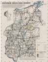
|---|---|
| Description: | This map highlights the fishing district and shows labeled rivers, lakes, cities, county boundaries and points of interest. The map includes a list of trai... |
If you didn't find the material you searched for, our Library Reference Staff can help.
Call our reference desk at 608-264-6535 or email us at: