 Filter: Categories of Wisconsin Historical Images
Filter: Subject of Parks
Filter: Subject of buses
Filter: Categories of Wisconsin Historical Images
Filter: Subject of Parks
Filter: Subject of buses
| Date: | |
|---|---|
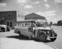
| Description: | A teacher waiting for students in the doorway of a school bus parked in the driveway near a brick building. A driver and other adults are visible in the in... |

| Date: | 07 22 1952 |
|---|---|
| Description: | A school bus driver and three campers are standing next to the bus which transports campers to and from the Brownie Day Camp at Hoyt Park. Left to right: S... |

| Date: | |
|---|---|
| Description: | View of an auto bus parked on a dirt road. The driver sits behind the steering wheel. |

| Date: | 1993 |
|---|---|
| Description: | Color photo of a man and a woman assisting a girl on a wheelchair lift for a model 3600 Special Needs bus. The "International" emblem is on the front of th... |

| Date: | 1936 |
|---|---|
| Description: | Street map of the City of Milwaukee and surrounding suburbs indicating various mass transit lines. There is an index to Milwaukee streets at the right of t... |

| Date: | 1960 |
|---|---|
| Description: | View looking down on Pinckney Street, with a section of Capitol park, from the Belmont Hotel. |

| Date: | 1927 |
|---|---|
| Description: | This map shows street car lines, bus routes, railroads, proposed city boundary lines, wards, public schools, blocks & house numbers, Lake Michigan, one mil... |

| Date: | 1930 |
|---|---|
| Description: | This map shows streets, railways, bus lines, railroads, roads, parks, cemeteries, Lake Michigan, and a proposed harbor. Also included is a legend and on th... |

| Date: | 1968 |
|---|---|
| Description: | Elevated view of 946 vehicles lined up at the Clark County fairgrounds awaiting their drivers for the largest drive-away ever held by International Harvest... |

| Date: | 2004 |
|---|---|
| Description: | This map shows ATMs, houses of worship, hotels, parking ramps, public parking, union cab stands, bus stops, business district, parks and public areas, gove... |
If you didn't find the material you searched for, our Library Reference Staff can help.
Call our reference desk at 608-264-6535 or email us at: