Filter: Categories of Wisconsin Historical Images
Filter: Subject of Parks
Filter: Subject of aerial photographs
Filter: Categories of Wisconsin Historical Images
Filter: Subject of Parks
Filter: Subject of aerial photographs
| Date: | |
|---|---|
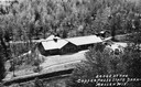
| Description: | Aerial view of a shelter house at Copper Falls State Park. |

| Date: | 1930 |
|---|---|
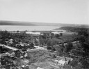
| Description: | Aerial view of Carson Park, Half Moon Lake and part of the West Side in the foreground. The municipal bath house is on the lake shore in the foreground. A ... |
| Date: | |
|---|---|
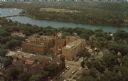
| Description: | Aerial view of the hospital along the banks of a river, with a bridge on the far left. Beyond the river is a baseball park. On the back of the card is writ... |
| Date: | 1924 |
|---|---|
| Description: | Aerial view looking southwest over Madison's Vilas Park. |
| Date: | 1930 |
|---|---|
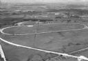
| Description: | Aerial view of the Dane County fairgrounds, including several buildings and a track. |

| Date: | 1930 |
|---|---|
| Description: | Aerial view of Tenney Park, including the lagoon, residences surrounding the park, and the shoreline of Lake Mendota on bottom left. |

| Date: | 1930 |
|---|---|
| Description: | Aerial view of Hoyt Park including the surrounding neighborhoods. Resurrection Cemetery can be seen at the upper right of the image. |
| Date: | 1957 |
|---|---|
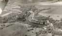
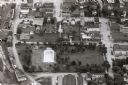
| Description: | Aerial view of downtown, including park, church, and stores. |

| Date: | 09 1918 |
|---|---|
| Description: | Elevated view of the U.S. Government War Exposition grounds at Grant Park. |

| Date: | 02 06 1948 |
|---|---|
| Description: | Aerial photograph of Madison's west side looking northeast along Speedway Road. Visible are Forest Hill and Resurrection Cemeteries, West High School, Hoyt... |

| Date: | 02 06 1948 |
|---|---|
| Description: | Aerial view of west side, looking south along Glenway Street. Visible are the reservoir, Lake Wingra, Forest Hill and Resurrection Cemetery, Hoyt Park. Maj... |

| Date: | 02 06 1948 |
|---|---|
| Description: | Aerial photograph looking northwest across the reservoir on Glenway Street. Featured are Hoyt and Quarry Parks, Resurrection Cemetery. Major streets are Fr... |

| Date: | 02 06 1948 |
|---|---|
| Description: | Looking north along Glenway Street. Visible are the reservoir, Hoyt and Quarry Parks, Resurrection and Forest Hill Cemeteries, Rentschler Greenhouses, Fore... |

| Date: | 02 06 1948 |
|---|---|
| Description: | Looking southeast across Speedway Road. Visible are the reservoir on Glenway Street, Hoyt Park, Resurrection and Forest Hill cemeteries, Glenway Golf cours... |

| Date: | 1953 |
|---|---|
| Description: | Aerial view looking north from the foot of Milwaukee's main thoroughfare, Wisconsin Avenue. Lincoln Memorial Drive winds its way along the lagoon in Juneau... |

| Date: | |
|---|---|
| Description: | An aerial view of downtown, including a baseball field in the lower left near a train station. |
| Date: | 1939 |
|---|---|
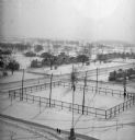
| Description: | Elevated view of village with snow on the ground. A tennis court, flag pole, and pedestrians are visible in the foreground. Behind the tennis court are roa... |

| Date: | 1955 |
|---|---|
| Description: | Aerial view of Schenk's Corners where Atwood Avenue and Winnebago Street cross, looking north west toward East Washington Avenue. ... |

| Date: | |
|---|---|
| Description: | Bird's eye view of Coney Island featuring the amusement park, shoreline, river, and a large boat. |
If you didn't find the material you searched for, our Library Reference Staff can help.
Call our reference desk at 608-264-6535 or email us at: