 Filter: Categories of Wisconsin Historical Images
Filter: Subject of Parks
Filter: County of Waukesha
Filter: Type of Map or Atlas
Filter: Categories of Wisconsin Historical Images
Filter: Subject of Parks
Filter: County of Waukesha
Filter: Type of Map or Atlas

| Date: | 02 1956 |
|---|---|
| Description: | This 1956 map of Waukesha County, Wisconsin, shows the township and range grid, towns, sections, cities and villages, roads, railroads, dams, airports, par... |

| Date: | 1898 |
|---|---|
| Description: | Map showing the contour depths of the lakes in northwestern Waukesha County, Wisconsin. Roads, railroads, depots, churches, schools, and hotels in the area... |

| Date: | 1965 |
|---|---|
| Description: | This basic street map shows roads, schools, parks and cemeteries and includes a street index in the lower margin. The map also shows a portion of Elm Grove... |
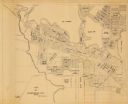
| Date: | |
|---|---|
| Description: | This map is a photocopy and shows the Oconomowoc River, Flower Lake, lot and block numbers and dimensions, additions, streets, C.M.St.P.&P. Ry., T.M.E.R.&L... |
If you didn't find the material you searched for, our Library Reference Staff can help.
Call our reference desk at 608-264-6535 or email us at: