 Filter: Categories of Wisconsin Historical Images
Filter: Subject of Parks
Filter: County of Washington
Filter: Categories of Wisconsin Historical Images
Filter: Subject of Parks
Filter: County of Washington
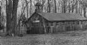
| Date: | 1905 |
|---|---|
| Description: | North Side Park building. There is a bell tower above the entrance. |

| Date: | |
|---|---|
| Description: | This map shows land parcels, streets and parks in the city of West Bend. The Milwaukee River is labeled on the left side. |

| Date: | 07 1955 |
|---|---|
| Description: | A tree-shaded bridge over a river, probably in a park. |
If you didn't find the material you searched for, our Library Reference Staff can help.
Call our reference desk at 608-264-6535 or email us at: