 Filter: Categories of Wisconsin Historical Images
Filter: Subject of Parks
Filter: County of Sawyer
Filter: Categories of Wisconsin Historical Images
Filter: Subject of Parks
Filter: County of Sawyer

| Date: | 1919 |
|---|---|
| Description: | This is a collection of three hand-colored plat maps. One map is a plat plan and includes annotations and an index that shows public land, business, indust... |

| Date: | 1923 |
|---|---|
| Description: | This map from the Wisconsin Lakes and Parks Association shows the area of a proposed state park, much of which is now part of the Flambeau River State Fore... |

| Date: | 1915 |
|---|---|
| Description: | This map shows a plat of city, wards, sections, land ownership by name, local streets, roads, railroads, local businesses, schools, and parks. This map is ... |
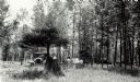
| Date: | 1932 |
|---|---|
| Description: | An early view of the Ojibwa Roadside Park. There are several automobiles in the background, and people sit on benches under the trees. |
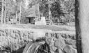
| Date: | 07 1939 |
|---|---|
| Description: | View across stone dam, with water flowing through the notch at Ojibwa Roadside Park. An automobile is parked near a large stone outdoor fireplace. There is... |
If you didn't find the material you searched for, our Library Reference Staff can help.
Call our reference desk at 608-264-6535 or email us at: