 Filter: Categories of Wisconsin Historical Images
Filter: Subject of Parks
Filter: County of Rock
Filter: Subject of human settlements
Filter: Categories of Wisconsin Historical Images
Filter: Subject of Parks
Filter: County of Rock
Filter: Subject of human settlements

| Date: | 1910 |
|---|---|
| Description: | The fountain in Court House Park. Caption reads: "Fountain in Court House Park, Janesville, Wis." |
| Date: | 1870 |
|---|---|
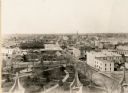
| Description: | Elevated view looking down Court Street in Janesville toward the west. |

| Date: | 1908 |
|---|---|
| Description: | View towards people standing on the shoreline near a boat landing at Yosts Park. A man and a dog are standing on the pier, and a group of people are in a b... |

| Date: | 1919 |
|---|---|
| Description: | Court House Park from Court Street looking southeast. The Civil War monument can be seen near the center, behind is the old courthouse which was replaced ... |

| Date: | |
|---|---|
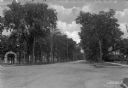
| Description: | View across lawn of First Congregational Church. The view is perhaps taken from a park, which has trees and benches in the foreground. Caption reads: "Firs... |

| Date: | |
|---|---|
| Description: | View of City Park featuring a mounted cannon. There are houses and perhaps a church in the far background. Caption reads: City Park, Beloit, Wis." |
| Date: | |
|---|---|
| Description: | View of entrance to White Park from the intersection of College Street and Bushnell Street, which are unpaved. A young girl stands under the archway entran... |
| Date: | |
|---|---|
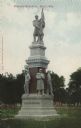
| Description: | Colorized postcard view of a soldier's monument statue in a city park. Caption reads: "Soldier's Monument, Beloit, Wis." |

| Date: | |
|---|---|
| Description: | Colorized postcard view of an octagonal bandstand in a city park. Caption reads: "Band Stand, City Park, Beloit, Wis." |

| Date: | 1955 |
|---|---|
| Description: | This map includes a street index and shows municipal golf course, parks, schools, cemeteries, Janesville County Club, and industrial sites. The back of the... |

| Date: | 1900 |
|---|---|
| Description: | This map includes an index of streets and schools, and shows parks and public lands, as well as industrial sites. |

| Date: | 1973 |
|---|---|
| Description: | This map includes an index of streets and schools and also shows parks, schools and public lands, and industrial sites. Portions of the map are in green an... |

| Date: | 1900 |
|---|---|
| Description: | This map is indexed and shows numbering system, public buildings and parks, wards, and voting booths. |

| Date: | 1873 |
|---|---|
| Description: | This map shows land ownership by name, local streets, railroads, parks, college grounds, schools, cemeteries, and part of Rock River. The upper left margin... |

| Date: | 10 1969 |
|---|---|
| Description: | A street map of Janesville showing the block numbers on each street. Other landmarks are labeled such as chain stores, parks, schools, manufacturing compa... |
| Date: | |
|---|---|
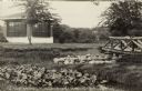
| Description: | A park with a gazebo and a rustic bridge over a stream. A boy is standing on the bridge, and another boy is standing below it behind the bank. Caption read... |

| Date: | |
|---|---|
| Description: | View across street towards a park. There are women sitting in a carriage at the curb. A fountain can be seen among the trees. Caption reads: "Court House P... |
If you didn't find the material you searched for, our Library Reference Staff can help.
Call our reference desk at 608-264-6535 or email us at: