Filter: Categories of Wisconsin Historical Images
Filter: Subject of Parks
Filter: County of Racine
Filter: Categories of Wisconsin Historical Images
Filter: Subject of Parks
Filter: County of Racine
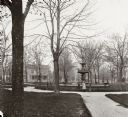
| Date: | 1888 |
|---|---|
| Description: | View down the center of a tree-lined path in West Park. |

| Date: | 1920 |
|---|---|
| Description: | Elevated view of Island Park, from Washington Park Drive, looking north from the west end of Kinzie Avenue bridge. |

| Date: | 1905 |
|---|---|
| Description: | Horlick Park, or Island Park, showing the Kinzie Avenue bridge. |
| Date: | 1920 |
|---|---|
| Description: | Island Park, looking south from the east end of Kinzie Avenue bridge. |

| Date: | 1937 |
|---|---|
| Description: | A log cabin in Heg Memorial Park, built in 1837. |

| Date: | 1987 |
|---|---|
| Description: | This 1987 map of Racine and Kenosha counties, Wisconsin, shows towns, sections, cities and villages, zip code boundaries, highways and roads, bicycle route... |

| Date: | 1903 |
|---|---|
| Description: | Map shows location of government buildings, schools, churches, parks, and other points of interest. The upper left hand margin features a "Reference" secti... |

| Date: | 1918 |
|---|---|
| Description: | Scene in a small city park showing a group of local women serving luncheon to soldiers recently returned from service in the first World War. Very possibly... |

| Date: | 1916 |
|---|---|
| Description: | This map of Racine includes an indexed street directory, schools, public buildings, parks, directory of buildings, and churches. The map includes 3 illustr... |

| Date: | 1935 |
|---|---|
| Description: | This map includes an index on the right margin of industrial plants, churches, schools, and public buildings. Streets, the Rock River, Lake Michigan, parks... |

| Date: | 1858 |
|---|---|
| Description: | This map shows lot and block numbers, landownership, buildings, railroads, roads, wards, points of interest, parks, and cemeteries. Also included are illus... |

| Date: | 01 18 1907 |
|---|---|
| Description: | This map shows Lake Michigan, streets, schools, churches, businesses, cemeteries, parks, and railroads. Relief is shown by contours; depths are shown by so... |
If you didn't find the material you searched for, our Library Reference Staff can help.
Call our reference desk at 608-264-6535 or email us at: