 Filter: Categories of Wisconsin Historical Images
Filter: Subject of Parks
Filter: County of Ozaukee
Filter: Categories of Wisconsin Historical Images
Filter: Subject of Parks
Filter: County of Ozaukee

| Date: | 2007 |
|---|---|
| Description: | This map of Cedarbug is a bird's-eye map with 8 inset views and an index. The map is a print out of the original map dated 1892 held at the Cedarburg Cultu... |
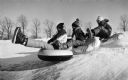
| Date: | 01 02 1988 |
|---|---|
| Description: | Bundled-up boys ride their tubes down an icy slope in Mee-Kwon Park. |

| Date: | 1989 |
|---|---|
| Description: | This pictorial map shows Lake Michigan, businesses with phone numbers, schools, parks, other points of interest, and includes a brief history of the town. ... |

| Date: | |
|---|---|
| Description: | Hand-colored view along shoreline of people posing in a rowboat near a boathouse. Other people are leaning against a railing and standing near a boathouse.... |
| Date: | |
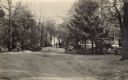
|---|---|
| Description: | Photographic postcard view of two men standing on a tree-lined road leading to water. Automobiles are parked on the right near a gazebo. Caption reads: "Hi... |
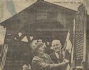
| Date: | 05 23 1965 |
|---|---|
| Description: | One of the last covered bridges in Wisconsin, located in Cedarburg, received an official state historical marker. The Last Covered Bridge historical marker... |
If you didn't find the material you searched for, our Library Reference Staff can help.
Call our reference desk at 608-264-6535 or email us at: