 Filter: Categories of Wisconsin Historical Images
Filter: Subject of Parks
Filter: County of Milwaukee
Filter: Year of 1800-1899
Filter: Subject of transportation
Filter: Categories of Wisconsin Historical Images
Filter: Subject of Parks
Filter: County of Milwaukee
Filter: Year of 1800-1899
Filter: Subject of transportation

| Date: | 1882 |
|---|---|
| Description: | Bird's-eye views of various sections of Milwaukee. |
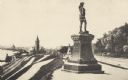
| Date: | 1895 |
|---|---|
| Description: | Side view of the statue on a plinth with Celtic designs, with his right hand holding a horn resting on his hip. The statue is located in Juneau Park. On th... |
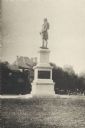
| Date: | 1893 |
|---|---|
| Description: | Side view of monument with plaque. Behind the statue is a road, trees, and the top of a building. A fire hydrant and a small group of people are on the ri... |
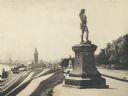
| Date: | 1893 |
|---|---|
| Description: | Statue of Leif Ericson is to the right of center in the foreground, with the figure facing the city. On the left is a hill with paths, a train station, ra... |
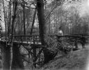
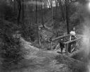
| Date: | 05 14 1899 |
|---|---|
| Description: | Aunt Helen and Syl stand on a rustic wooden bridge in Gully Lake Park. A pavilion is visible behind them through the trees. |
| Date: | 05 14 1899 |
|---|---|
| Description: | Syl and aunt Helen standing on a small rustic wooden bridge in Gully Lake Park surrounded by trees and steep hills. |
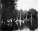
| Date: | 07 30 1899 |
|---|---|
| Description: | View across pond of Syl at Soldiers Home with aunt Helen standing on a landing near a boat and a flagpole. There is a large group of people gathered around... |

| Date: | 1878 |
|---|---|
| Description: | This map shows block numbers, wards, roads, railroads, parks, and selected buildings and includes a "Milwaukee city street guide" as well as a guide to pub... |

| Date: | 1887 |
|---|---|
| Description: | This map shows block numbers, roads, railroads, wards, and selected buildings. The map includes a "Milwaukee city street guide" and index to public buildin... |

| Date: | 1891 |
|---|---|
| Description: | A hand-colored map of Milwaukee County, Wisconsin that shows the township and range system, sections, towns, roads, railroads and rail stations, cities and... |

| Date: | 1896 |
|---|---|
| Description: | Map highlighting parks and other points of interest in Milwaukee. |

| Date: | 1891 |
|---|---|
| Description: | This map shows railroads, street railways, roads, wards, block numbers, parks, and one mile concentric circles indicating distance from Post Office. Also i... |

| Date: | 1892 |
|---|---|
| Description: | This map shows water pipes, hydrants, stop cocks, check valves, fire cysterns, and manholes. Also shown are block numbers, streets, railroads, parks, cemet... |

| Date: | 1892 |
|---|---|
| Description: | This map shows schools, engine houses, railroads, street railways, wards, parks, cemeteries, block numbers, a street index, explanations, and general refer... |

| Date: | 1893 |
|---|---|
| Description: | This map covers west to Wauwatosa, north to North Milwaukee, and south to South Milwaukee and shows street railways, city limits, parks, roads, railroads, ... |

| Date: | 1893 |
|---|---|
| Description: | This map shows city wards, block numbers, parks, cemeteries, roads, railroads, selected buildings, and Lake Michigan. Also included are indexes to streets,... |

| Date: | 1897 |
|---|---|
| Description: | This map shows city wards, block numbers, parks, cemeteries, roads, railroads, Lake Michigan, and selected buildings. Also included are indexes to streets,... |

| Date: | 1898 |
|---|---|
| Description: | This map shows city wards, block numbers, parks, cemeteries, roads, railroads, Lake Michigan, and selected buildings. Also included are indexes "Milwaukee ... |

| Date: | 1894 |
|---|---|
| Description: | This map shows sewers, intercepting sewers, manholes, block numbers, streets, railroads, parks, cemeteries, and Lake Michigan. The right margin reads: "Tot... |

| Date: | 1896 |
|---|---|
| Description: | This map shows streets, wards, railroads, parks, cemeteries, and Lake Michigan. Also included are explanations and an index of points of interest. |
If you didn't find the material you searched for, our Library Reference Staff can help.
Call our reference desk at 608-264-6535 or email us at: