 Filter: Categories of Wisconsin Historical Images
Filter: Subject of Parks
Filter: County of Milwaukee
Filter: Subject of human settlements
Filter: Categories of Wisconsin Historical Images
Filter: Subject of Parks
Filter: County of Milwaukee
Filter: Subject of human settlements

| Date: | 08 15 1942 |
|---|---|
| Description: | Children riding ponies in a roped-off area in a park at a Civilian Defense Rally. |
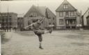
| Date: | |
|---|---|
| Description: | Side view of a man presumably kicking a football. He is in a lot, and houses are in the background. |
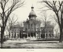
| Date: | 1885 |
|---|---|
| Description: | Exterior view of the old Court House with park in front of it. |
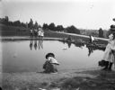
| Date: | 08 28 1898 |
|---|---|
| Description: | Syl playing with toy boats at a small pond at Reservoir Park. Other children and adults are around the pond which is on a hill. In the background below the... |
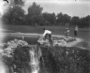
| Date: | 08 28 1898 |
|---|---|
| Description: | Syl playing with other children at reservoir park near a small waterfall. Toy boats are in the pond. |
| Date: | 07 30 1899 |
|---|---|
| Description: | View across pond of Syl at Soldiers Home with aunt Helen standing on a landing near a boat and a flagpole. There is a large group of people gathered around... |

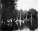
| Date: | 06 09 1901 |
|---|---|
| Description: | View across water of rowboats and canoes on small lake, perhaps Lake Park. On the far shoreline a large crowd is gathered, and on a hill behind them a buil... |

| Date: | |
|---|---|
| Description: | Elevated exterior view of Everett Street Station, also called the New Passenger Station facing Fourth Ward Park (later renamed Zeidler Park). |

| Date: | |
|---|---|
| Description: | American Legion floral emblem on the east slope of Milwaukee's Kilbourne Park Reservoir. Caption reads: "American Legion Floral Emblem, Kilbourn Park, Milw... |

| Date: | 1878 |
|---|---|
| Description: | This map shows block numbers, wards, roads, railroads, parks, and selected buildings and includes a "Milwaukee city street guide" as well as a guide to pub... |

| Date: | 1887 |
|---|---|
| Description: | This map shows block numbers, roads, railroads, wards, and selected buildings. The map includes a "Milwaukee city street guide" and index to public buildin... |
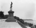
| Date: | 09 1900 |
|---|---|
| Description: | View of a statue in Juneau Park, created by American sculptor Anne Whitney in 1887. The statue is a replica of the original which resides in Boston, Massac... |
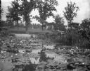
| Date: | 1900 |
|---|---|
| Description: | View of a lily pond in Mitchell Park. A man is working among the plants along the shoreline in the middle background. |

| Date: | 1891 |
|---|---|
| Description: | A hand-colored map of Milwaukee County, Wisconsin that shows the township and range system, sections, towns, roads, railroads and rail stations, cities and... |

| Date: | 1902 |
|---|---|
| Description: | A map of Milwaukee County, Wisconsin that shows the township and range system, sections, towns, roads, railroads and rail stations, cities and villages, po... |

| Date: | 1922 |
|---|---|
| Description: | A bird's-eye map that shows the Milwaukee Parkway as contemplated by the Milwaukee County Planning Commission. The map identifies the roads and parks throu... |

| Date: | 1940 |
|---|---|
| Description: | Map of Milwaukee County showing the metropolitan area, in yellow, and the proposed connecting of parkways and boulevards in green. The map also identifies ... |

| Date: | 1976 |
|---|---|
| Description: | A street map of Milwaukee County, Wisconsin that identifies the location of schools, hospitals, parks, beaches, streets, freeways, both planned or under co... |

| Date: | 1993 |
|---|---|
| Description: | A map of Milwaukee County, indicating the locations of toxic sites and the types of toxic sites, ranging from those listed as a superfund site, industry re... |

| Date: | 1914 |
|---|---|
| Description: | A hand-drawn and colored map of the Milwaukee Township, showing how lands were used, included are parks, cemeteries, private grounds, and speculative land.... |
If you didn't find the material you searched for, our Library Reference Staff can help.
Call our reference desk at 608-264-6535 or email us at: