 Filter: Categories of Wisconsin Historical Images
Filter: Subject of Parks
Filter: County of Ashland
Filter: Categories of Wisconsin Historical Images
Filter: Subject of Parks
Filter: County of Ashland
| Date: | |
|---|---|
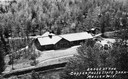
| Description: | Aerial view of a shelter house at Copper Falls State Park. |

| Date: | 1890 |
|---|---|
| Description: | Bird's-eye map of Ashland, viewed from Lake Superior, with insets of Prentice Park and Fishery. Population 16,000. Increase in Ten Years, 11,000. |

| Date: | 12 11 1936 |
|---|---|
| Description: | Blueprint design for seats for Copper Falls State Park. |

| Date: | 05 21 1936 |
|---|---|
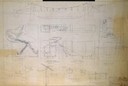
| Description: | Blueprint design for a trail side shelter at Copper Falls State Park. |
| Date: | 01 09 1940 |
|---|---|
| Description: | Blueprint design for a suspension footbridge for Copper Falls State Park. |
| Date: | |
|---|---|
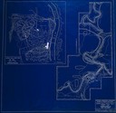
| Description: | Blueprint design of the master plan for Copper Falls State Park. |

| Date: | 1930 |
|---|---|
| Description: | Six girls sit on a stone wall beside Mammoth Spring in Prentice Park. |
| Date: | |
|---|---|
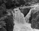
| Description: | Elevated view of the falls. There are three men at the top of the falls. |
| Date: | 1939 |
|---|---|
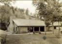
| Description: | The shelter house at Copper Falls State Park. |
| Date: | 07 1937 |
|---|---|
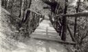
| Description: | View down picturesque suspension bridge across one of the gullies at Copper Falls State Park. |

| Date: | 1936 |
|---|---|
| Description: | View across lawn of Chequamegon National Forest Guard Station sign in front of one-story guard station building with two front doors. |

| Date: | |
|---|---|
| Description: | Historical marker identifying the location of the first house in Wisconsin built between Washburn and Ashland in 1658. |

| Date: | 1935 |
|---|---|
| Description: | View of the Ashland Band Shell with benches, trees, and what is today Highway 2 in the foreground. On the left is a large metal tower, and in the backgroun... |

| Date: | 1947 |
|---|---|
| Description: | This map of Ashland is a cadastral map showing some rural landowners and includes index to points of interest. The map shows roads, railroads, parks, cemet... |

| Date: | 1900 |
|---|---|
| Description: | This map is shows land in white and water in blue and is indexed for parks, points of interest, schools, churches, and recreational areas. The map shows lo... |

| Date: | 1930 |
|---|---|
| Description: | A child is holding out a bowl to a pillar from which water is cascading down into a spring. In the background, two other children are walking up a dirt pat... |
| Date: | 08 1952 |
|---|---|
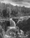
| Description: | Copper Falls in Copper Falls State Park. The falls are on the Bad River. A group of people are standing on the rocks on the right. Trees are in the backgro... |

| Date: | 1950 |
|---|---|
| Description: | Copper Falls plunging over rocks on the Bad River in Copper Falls State Park. |
If you didn't find the material you searched for, our Library Reference Staff can help.
Call our reference desk at 608-264-6535 or email us at: