 Filter: Categories of Wisconsin Historical Images
Filter: Subject of Outdoor recreation
Filter: Subject of streams
Filter: Categories of Wisconsin Historical Images
Filter: Subject of Outdoor recreation
Filter: Subject of streams
| Date: | |
|---|---|
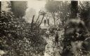
| Description: | A group of four boys in a wooded area. Two boys are standing on a small bridge, and the other two are walking along a small creek. |

| Date: | 1964 |
|---|---|
| Description: | This 1964 maps shows roads, boat landings and marinas, campgrounds, canoe trails and portages, and lakes and streams in parts of Vilas, Oneida, and Iron co... |

| Date: | 1986 |
|---|---|
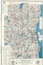
| Description: | This late 1980s map of Price County, Wisconsin, shows facilities and lands open for public recreation, hunter walking trails and ski trails, campgrounds, b... |
| Date: | |
|---|---|
| Description: | I'll show you all the imported graces and you shall see New Fontainebleau |

| Date: | |
|---|---|
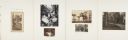
| Description: | Page from Sue Ann Hackett Blue Album displaying several photographs from Kaubashine Creek trip. Includes campers in boats near a dock, and water and wooded... |
| Date: | 1960 |
|---|---|
| Description: | This map shows lakes arranged by county, depth maps of selected larger lakes, and enlargements of Mississippi River areas. The map also includes locations ... |

| Date: | 1948 |
|---|---|
| Description: | Slightly elevated view of two men snowshoeing along a flowing stream near Trout Lake. |
If you didn't find the material you searched for, our Library Reference Staff can help.
Call our reference desk at 608-264-6535 or email us at: