 Filter: Categories of Wisconsin Historical Images
Filter: Subject of Outdoor photography
Filter: Subject of maps
Filter: Categories of Wisconsin Historical Images
Filter: Subject of Outdoor photography
Filter: Subject of maps
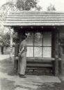
| Date: | 1939 |
|---|---|
| Description: | Man looking at a map of Copper Falls State Park, which is on display to assist visitors. |

| Date: | 1870 |
|---|---|
| Description: | Bird's-eye view of the city of Manitowoc with a population of 5,168 inhabitants as it appears in 1870, the year the village was granted a city charter by t... |
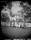
| Date: | 1874 |
|---|---|
| Description: | The Ole Wettlesen family poses in the yard in front of a picket fence with women knitting. Two standing men appear to be examining an unfolded map. The fra... |
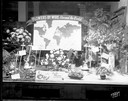
| Date: | 12 05 1952 |
|---|---|
| Description: | Rentschler Floral Company Floral Telegraph Delivery window display, "Flower's-by-Wire, Around the World." |
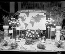
| Date: | 12 08 1952 |
|---|---|
| Description: | Rentschler Floral Company, 230 State Street, Floral Telegraph Delivery window display with plants and floral arrangements, banner with world map and "Flowe... |

| Date: | 1920 |
|---|---|
| Description: | Calumet Harbor on Lake Winnebago. On the left is a map, and on the right are two images, one captioned: "Calumet Harbor". |
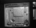
| Date: | 03 17 1947 |
|---|---|
| Description: | Wisconsin Felton Sporting Goods window display of state map and pairings chart for 1947 State Basketball Tournament. "Welcome State Tournament Fans." |
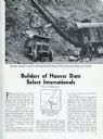
| Date: | 03 1932 |
|---|---|
| Description: | Page from International Trail magazine featuring an article about the use of International trucks for the construction of the Hoover Dam. The title ... |
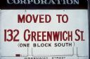
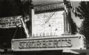
| Date: | 1969 |
|---|---|
| Description: | A sign reads that a business has "Moved to 132 Greenwich St. (one block south)." Along with the written description, there is a small map to show where the... |
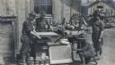
| Date: | 1918 |
|---|---|
| Description: | Army engineers at Camp Curtiss, demonstrating zincographic equipment. Zincography was a form of printing for large maps using zinc plates. |
| Date: | |
|---|---|
| Description: | A sign above a large map of Wisconsin counties is in Latin: "Pro Deo Et Patria," meaning For God and Country, and on the left is a decorated cross, on top ... |

| Date: | 1930 |
|---|---|
| Description: | Exterior view of the Triangle filling station on Highway 12, which sold gasoline, ice, and other items. A man stands in front by the gas pump, and a map of... |

| Date: | 1969 |
|---|---|
| Description: | Photographic holiday postcard of a couple on their bikes in a driveway. Shrubs and palm trees surround them. A map of the Pacific Ocean is in the backgroun... |

| Date: | 1942 |
|---|---|
| Description: | Officers and non-commissioned officers squatting to consult a map on the ground near Fort Davis, Panama. The men are wearing fatigues and have sub-machine ... |

| Date: | 1958 |
|---|---|
| Description: | Meeting of the 26th of July Movement in the woods of Oriente Province during the Cuban Revolution. Fidel Castro, Juan Almeida Bosque and Vilma Espin crouch... |

| Date: | 1958 |
|---|---|
| Description: | Meeting of the 26th of July Movement in the woods of Oriente Province during the Cuban Revolution. A number of participants, including Vilma Espin and Juan... |

| Date: | 1958 |
|---|---|
| Description: | Meeting of the 26th of July Movement in Oriente Province during the Cuban Revolution. A number of participants, including Vilma Espin, Raúl Castro and Juan... |

| Date: | 1958 |
|---|---|
| Description: | Meeting of the 26th of July Movement in Oriente Province during the Cuban Revolution. Vilma Espin and Fidel Castro crouch over a map spread on the ground.... |

| Date: | 1958 |
|---|---|
| Description: | Meeting of the 26th of July Movement in Oriente Province during the Cuban Revolution. Vilma Espin stands in the middle with a gun, and Raúl Castro and Juan... |

| Date: | 1936 |
|---|---|
| Description: | View across road of a one-story building, Day's Service Station, with gasoline pumps and signs and a map out front. The signs read “Straight Ahead, 10 Mi. ... |
If you didn't find the material you searched for, our Library Reference Staff can help.
Call our reference desk at 608-264-6535 or email us at: