 Filter: Categories of Wisconsin Historical Images
Filter: Subject of Outdoor life
Filter: Categories of Wisconsin Historical Images
Filter: Subject of Outdoor life
| Date: | |
|---|---|
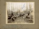
| Description: | A group of men relax outdoors after fishing. Most are seated on the grass, while one man sits on and boat and another stands holding the day's catch. There... |

| Date: | |
|---|---|
| Description: | Several men relaxing on the grass at the edge of a lake. There are boats pulled up on the shore near them. The man standing on the far right with his hand ... |

| Date: | 1948 |
|---|---|
| Description: | This colored road map shows automobile roads in Wisconsin as well as portions of nearby states.Information on the quality and type of any road shown (bitum... |

| Date: | 1966 |
|---|---|
| Description: | This colored road map shows automobile roads in Wisconsin as well as portions of nearby states. A map key indicates relative sizes of cities and towns. On ... |

| Date: | 1971 |
|---|---|
| Description: | This colored map displays Wisconsin and bordering areas of Iowa, Minnesota, and Michigan. There is color-coding on the map to indicate National Forests, an... |

| Date: | 1973 |
|---|---|
| Description: | This colored map displays Wisconsin and bordering areas of Iowa, Minnesota, and Michigan. There is color-coding on the map to indicate National Forests, a... |

| Date: | 1975 |
|---|---|
| Description: | This colored road map of Wisconsin displays "Featured Points of Interest" and "Historical Points of Interest" in the state, including three color photograp... |

| Date: | 1973 |
|---|---|
| Description: | This map displays, in color, Wisconsin and bordering areas of Iowa, Minnesota, Illinois, and Michigan. At the bottom is a map key indicating road classifi... |

| Date: | 1976 |
|---|---|
| Description: | This color map displays Wisconsin and bordering areas of Iowa, Minnesota, Illinois, and Michigan. At the bottom is a map key indicating road classification... |

| Date: | 1976 |
|---|---|
| Description: | This colored map displays Wisconsin and portions of bordering states, including a detailed map of the Wisconsin Dells area. Surrounding the map are multipl... |

| Date: | 1977 |
|---|---|
| Description: | This colored map displays Wisconsin and portions of bordering states, including a detailed map of the Wisconsin Dells area. Surrounding the map are multipl... |

| Date: | 1980 |
|---|---|
| Description: | The general theme of this black and white map is "Discover and Enjoy Wisconsin." The front of the map depicts driving tours numbered 1 through 12; each to... |

| Date: | 1962 |
|---|---|
| Description: | This colored map represents "Tour #2" of a series of driving tours of the state published by the Sperry & Hutchinson Company, in order to "help you enjoy W... |

| Date: | 1962 |
|---|---|
| Description: | This colored map represents "Tour #1" of a series of driving tours of the state published by the Sperry & Hutchinson Company, in order to "help you enjoy W... |

| Date: | 1949 |
|---|---|
| Description: | This multi-colored promotional map for recreational activities in the Hayward area includes a graphic of distances from Midwestern cities to Hayward, with ... |

| Date: | |
|---|---|
| Description: | Two children are kneeling while sawing a log of wood with a hand saw, while a third child is watching in the center. Behind them are picnic tables in the s... |

| Date: | |
|---|---|
| Description: | A wood sign in the foreground reads: "Roadside Picnic Area, Kettle Moraine State Forest, Department of Natural Resources." A few people are cross country s... |

| Date: | 03 1978 |
|---|---|
| Description: | A family of five are outdoors standing around or sitting on their two snowmobiles as they take a break to drink and eat. |
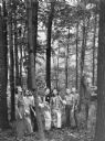
| Date: | 1939 |
|---|---|
| Description: | An unidentified man is leading a group of young women on an educational walk in the Kettle Moraine State Forest. He is pointing upward near a large tree. T... |
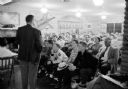
| Date: | 05 1955 |
|---|---|
| Description: | Carl Wettengel, a board member of the rifle club, addressing a room full of parents and youth members inside the clubhouse about the history of the group. ... |
If you didn't find the material you searched for, our Library Reference Staff can help.
Call our reference desk at 608-264-6535 or email us at: