 Filter: Categories of Wisconsin Historical Images
Filter: Subject of Outdoor life
Filter: Subject of winter sports
Filter: Subject of fishing
Filter: Categories of Wisconsin Historical Images
Filter: Subject of Outdoor life
Filter: Subject of winter sports
Filter: Subject of fishing
| Date: | |
|---|---|
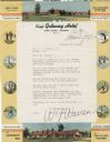
| Description: | Letterhead of the King's Gateway Hotel of Land O' Lakes, Wisconsin, with header and footer color views of the hotel and neighboring Gateway Inn. There are ... |
| Date: | |
|---|---|
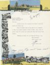
| Description: | Letterhead of the King's Gateway Hotel in Land O' Lakes, Wisconsin, with header and footer views of the hotel and nearby Gateway Inn in color, and overlapp... |

| Date: | 01 1954 |
|---|---|
| Description: | Three people ice fishing on Salmo Pond near Black Earth. |

| Date: | 01 1954 |
|---|---|
| Description: | Harvey Gifford, of 2541 East Johnson Street in Madison, chops a hole in the ice on Salmo Pond near Back Earth in preparation for ice fishing, where he thin... |

| Date: | 01 1954 |
|---|---|
| Description: | Mrs. Arthur Fecht, Highland, attaches bait to her line while ice fishing on Salmo Pond near Black Earth. |

| Date: | 01 1954 |
|---|---|
| Description: | Kenneth Kruse, a Madison policeman living at 5009 Flambeau Road, and his son Billy wait patiently for a nibble while ice fishing on Salmo Pond near Black E... |

| Date: | 01 1954 |
|---|---|
| Description: | Fisherman Walter Meske of Watertown holds up a fish he caught while ice fishing on Salmo Pond near Black Earth. |

| Date: | 1966 |
|---|---|
| Description: | This colored road map shows automobile roads in Wisconsin as well as portions of nearby states. A map key indicates relative sizes of cities and towns. On ... |

| Date: | 1971 |
|---|---|
| Description: | This colored map displays Wisconsin and bordering areas of Iowa, Minnesota, and Michigan. There is color-coding on the map to indicate National Forests, an... |

| Date: | 1973 |
|---|---|
| Description: | This colored map displays Wisconsin and bordering areas of Iowa, Minnesota, and Michigan. There is color-coding on the map to indicate National Forests, a... |

| Date: | 1975 |
|---|---|
| Description: | This colored road map of Wisconsin displays "Featured Points of Interest" and "Historical Points of Interest" in the state, including three color photograp... |

| Date: | 1973 |
|---|---|
| Description: | This map displays, in color, Wisconsin and bordering areas of Iowa, Minnesota, Illinois, and Michigan. At the bottom is a map key indicating road classifi... |

| Date: | 1976 |
|---|---|
| Description: | This color map displays Wisconsin and bordering areas of Iowa, Minnesota, Illinois, and Michigan. At the bottom is a map key indicating road classification... |

| Date: | 1976 |
|---|---|
| Description: | This colored map displays Wisconsin and portions of bordering states, including a detailed map of the Wisconsin Dells area. Surrounding the map are multipl... |

| Date: | 1977 |
|---|---|
| Description: | This colored map displays Wisconsin and portions of bordering states, including a detailed map of the Wisconsin Dells area. Surrounding the map are multipl... |

| Date: | 1962 |
|---|---|
| Description: | This colored map represents "Tour #2" of a series of driving tours of the state published by the Sperry & Hutchinson Company, in order to "help you enjoy W... |

| Date: | 1962 |
|---|---|
| Description: | This colored map represents "Tour #1" of a series of driving tours of the state published by the Sperry & Hutchinson Company, in order to "help you enjoy W... |

| Date: | 1949 |
|---|---|
| Description: | This multi-colored promotional map for recreational activities in the Hayward area includes a graphic of distances from Midwestern cities to Hayward, with ... |
If you didn't find the material you searched for, our Library Reference Staff can help.
Call our reference desk at 608-264-6535 or email us at: