 Filter: Categories of Wisconsin Historical Images
Filter: Subject of Outdoor life
Filter: Subject of tourism
Filter: Categories of Wisconsin Historical Images
Filter: Subject of Outdoor life
Filter: Subject of tourism
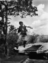
| Date: | 05 1980 |
|---|---|
| Description: | Ashley Bennett II, age 46, son of original jumper, at Stand Rock. |
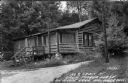
| Date: | |
|---|---|
| Description: | Exterior view of the log cabin. Caption reads: "No 2 Cabin at Virgin Timber Lodge on Moose Lake, Hayward, Wis." |
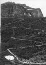
| Date: | |
|---|---|
| Description: | Elevated view of a donkey train going up a zig-zag trail along the mountainside in Glacier National Park. |
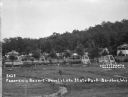
| Date: | 1925 |
|---|---|
| Description: | View of two-seat lawn swings amid trees on a lawn. Cabins are along a hill in the background. There is an information center on the far left. |

| Date: | 1936 |
|---|---|
| Description: | This pictorial tourist map from the Wisconsin Conservation Commission depicts vacation activities and identifies tourist destinations throughout the state.... |

| Date: | 1938 |
|---|---|
| Description: | This 1938 tourist map of Douglas County, Wisconsin, identifies game refuges, fishing locations, and other outdoor recreation opportunities in the county. A... |

| Date: | 1970 |
|---|---|
| Description: | This map is intended for tourists of La Crosse. The cover features images of farms and natural land and reads: "friends are but strangers... we have yet to... |

| Date: | 1966 |
|---|---|
| Description: | This colored road map shows automobile roads in Wisconsin as well as portions of nearby states. A map key indicates relative sizes of cities and towns. On ... |

| Date: | 1971 |
|---|---|
| Description: | This colored map displays Wisconsin and bordering areas of Iowa, Minnesota, and Michigan. There is color-coding on the map to indicate National Forests, an... |

| Date: | 1973 |
|---|---|
| Description: | This colored map displays Wisconsin and bordering areas of Iowa, Minnesota, and Michigan. There is color-coding on the map to indicate National Forests, a... |

| Date: | 1975 |
|---|---|
| Description: | This colored road map of Wisconsin displays "Featured Points of Interest" and "Historical Points of Interest" in the state, including three color photograp... |

| Date: | 1973 |
|---|---|
| Description: | This map displays, in color, Wisconsin and bordering areas of Iowa, Minnesota, Illinois, and Michigan. At the bottom is a map key indicating road classifi... |

| Date: | 1976 |
|---|---|
| Description: | This color map displays Wisconsin and bordering areas of Iowa, Minnesota, Illinois, and Michigan. At the bottom is a map key indicating road classification... |

| Date: | 1977 |
|---|---|
| Description: | This colored map displays Wisconsin and portions of bordering states, including a detailed map of the Wisconsin Dells area. Surrounding the map are multipl... |

| Date: | 1980 |
|---|---|
| Description: | The general theme of this black and white map is "Discover and Enjoy Wisconsin." The front of the map depicts driving tours numbered 1 through 12; each to... |
If you didn't find the material you searched for, our Library Reference Staff can help.
Call our reference desk at 608-264-6535 or email us at: