 Filter: Categories of Wisconsin Historical Images
Filter: Subject of Outdoor life
Filter: Subject of roads
Filter: Categories of Wisconsin Historical Images
Filter: Subject of Outdoor life
Filter: Subject of roads
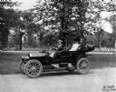
| Date: | 07 14 1910 |
|---|---|
| Description: | Woman and two passengers driving an International J-30 passenger car with its top down through a city park. Also known as the IHC 30, the J-30 was produced... |
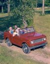
| Date: | |
|---|---|
| Description: | Color advertising photograph of two men and two younger women riding along a rural road in an International Scout convertible pickup. |
| Date: | 05 1959 |
|---|---|
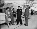
| Description: | Trailer Convention Officials, including the Mayor and the Police Chief, standing outside near an Airstreamer. |
| Date: | 1925 |
|---|---|
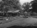
| Description: | An information station advertising: free camping, with hot sandwiches and coffee, and tents and cots for sale. On a utility line pole, there are signs for ... |
| Date: | 1935 |
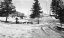
|---|---|
| Description: | Winter scene with people sledding, dog sledding, snowshoeing, and preparing for snowshoeing at Lakewood Country Club. |
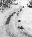
| Date: | 02 19 1978 |
|---|---|
| Description: | "Sledding on the Brewery Hill. (Top to bottom) Julie Wiedmeyer, 10, Tammy Konrath, 9, and Vicky Konrath, 7." |
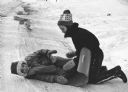
| Date: | 02 19 1978 |
|---|---|
| Description: | "Having fun on the Brewery Hill. Vicky Konrath and Julie Wiedmeyer." |

| Date: | 1936 |
|---|---|
| Description: | This pictorial tourist map from the Wisconsin Conservation Commission depicts vacation activities and identifies tourist destinations throughout the state.... |
| Date: | 08 1996 |
|---|---|
| Description: | Shirley Widmer biking on McArthur Road. |

| Date: | 09 2000 |
|---|---|
| Description: | Wagon Train continues on McArther Road. |

| Date: | 1948 |
|---|---|
| Description: | This colored road map shows automobile roads in Wisconsin as well as portions of nearby states.Information on the quality and type of any road shown (bitum... |

| Date: | 1966 |
|---|---|
| Description: | This colored road map shows automobile roads in Wisconsin as well as portions of nearby states. A map key indicates relative sizes of cities and towns. On ... |

| Date: | 1971 |
|---|---|
| Description: | This colored map displays Wisconsin and bordering areas of Iowa, Minnesota, and Michigan. There is color-coding on the map to indicate National Forests, an... |

| Date: | 1973 |
|---|---|
| Description: | This colored map displays Wisconsin and bordering areas of Iowa, Minnesota, and Michigan. There is color-coding on the map to indicate National Forests, a... |

| Date: | 1975 |
|---|---|
| Description: | This colored road map of Wisconsin displays "Featured Points of Interest" and "Historical Points of Interest" in the state, including three color photograp... |

| Date: | 1976 |
|---|---|
| Description: | This colored map displays Wisconsin and portions of bordering states, including a detailed map of the Wisconsin Dells area. Surrounding the map are multipl... |

| Date: | 1977 |
|---|---|
| Description: | This colored map displays Wisconsin and portions of bordering states, including a detailed map of the Wisconsin Dells area. Surrounding the map are multipl... |
If you didn't find the material you searched for, our Library Reference Staff can help.
Call our reference desk at 608-264-6535 or email us at: