 Filter: Categories of Wisconsin Historical Images
Filter: Subject of Outdoor life
Filter: Subject of rivers
Filter: Categories of Wisconsin Historical Images
Filter: Subject of Outdoor life
Filter: Subject of rivers
| Date: | |
|---|---|
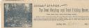
| Description: | Letterhead of Dudley Station, a hunting and trout fishing resort in Dudley, Wisconsin. On the left is an illustration of a fisherman holding a fishing pole... |

| Date: | 1936 |
|---|---|
| Description: | This pictorial tourist map from the Wisconsin Conservation Commission depicts vacation activities and identifies tourist destinations throughout the state.... |
| Date: | 1935 |
|---|---|
| Description: | View from shoreline of men fishing out of wooden rowboats on the Flambeau River below the flowage dam. One man is standing in the river. A shack is visible... |

| Date: | 1970 |
|---|---|
| Description: | This map is intended for tourists of La Crosse. The cover features images of farms and natural land and reads: "friends are but strangers... we have yet to... |

| Date: | 1948 |
|---|---|
| Description: | This colored road map shows automobile roads in Wisconsin as well as portions of nearby states.Information on the quality and type of any road shown (bitum... |

| Date: | 1946 |
|---|---|
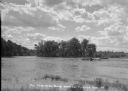
| Description: | Two canoes are pulled up on the shoreline in the Flambeau River State Forest. |
If you didn't find the material you searched for, our Library Reference Staff can help.
Call our reference desk at 608-264-6535 or email us at: