 Filter: Categories of Wisconsin Historical Images
Filter: Subject of Outdoor life
Filter: Subject of outdoor recreation
Filter: Year of 1900-1999
Filter: Categories of Wisconsin Historical Images
Filter: Subject of Outdoor life
Filter: Subject of outdoor recreation
Filter: Year of 1900-1999
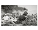
| Date: | 1916 |
|---|---|
| Description: | Picnic on the shores of Basswood Island, Apostle Islands. Those picnicking include Harriet Webb, C.A. Hull, H.W. Rodgers, Mrs. J. Austin, Elizabeth Baker, ... |
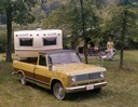
| Date: | 1972 |
|---|---|
| Description: | Color advertising photograph of a family of four camping out with an International 1110 Custom pickup and Hy-Lander trailer home. |

| Date: | 07 26 1930 |
|---|---|
| Description: | Ed Sullivan, age 11, 1119 W. Dayton Street, and Gordon Todd, 118 N. Charter Street, sitting in a tree in the 1100 block of W. Dayton Street, pursuing the t... |

| Date: | 07 11 1930 |
|---|---|
| Description: | Paul Vilbrandt, age 10, standing by a tree and ladder at the 1200 block of West Dayton Street, hoping to break the tree sitting record of Jimmie Clemons of... |
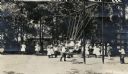
| Date: | 1915 |
|---|---|
| Description: | Children playing in a park playground, mainly on a large swing set. |

| Date: | 1936 |
|---|---|
| Description: | A view of the Marathon County Park. Many children are playing in the water surrounding a stone fountain, while others watch from the benches. |

| Date: | 1925 |
|---|---|
| Description: | Children are sitting on benches looking at books, and other children are playing in a sandbox at Happy Hearts Park. |

| Date: | 02 19 1978 |
|---|---|
| Description: | "Sledding on the Brewery Hill. (Top to bottom) Julie Wiedmeyer, 10, Tammy Konrath, 9, and Vicky Konrath, 7." |

| Date: | 02 19 1978 |
|---|---|
| Description: | "Having fun on the Brewery Hill. Vicky Konrath and Julie Wiedmeyer." |

| Date: | 1912 |
|---|---|
| Description: | A child in a stocking cap sleds down a course of piled snow at the side of the Hotz family home. |

| Date: | 1936 |
|---|---|
| Description: | This pictorial tourist map from the Wisconsin Conservation Commission depicts vacation activities and identifies tourist destinations throughout the state.... |

| Date: | 1973 |
|---|---|
| Description: | This colored map displays Wisconsin and bordering areas of Iowa, Minnesota, and Michigan. There is color-coding on the map to indicate National Forests, a... |

| Date: | 1975 |
|---|---|
| Description: | This colored road map of Wisconsin displays "Featured Points of Interest" and "Historical Points of Interest" in the state, including three color photograp... |

| Date: | 1973 |
|---|---|
| Description: | This map displays, in color, Wisconsin and bordering areas of Iowa, Minnesota, Illinois, and Michigan. At the bottom is a map key indicating road classifi... |

| Date: | 1976 |
|---|---|
| Description: | This color map displays Wisconsin and bordering areas of Iowa, Minnesota, Illinois, and Michigan. At the bottom is a map key indicating road classification... |

| Date: | 1976 |
|---|---|
| Description: | This colored map displays Wisconsin and portions of bordering states, including a detailed map of the Wisconsin Dells area. Surrounding the map are multipl... |

| Date: | 1977 |
|---|---|
| Description: | This colored map displays Wisconsin and portions of bordering states, including a detailed map of the Wisconsin Dells area. Surrounding the map are multipl... |

| Date: | 1980 |
|---|---|
| Description: | The general theme of this black and white map is "Discover and Enjoy Wisconsin." The front of the map depicts driving tours numbered 1 through 12; each to... |

| Date: | 1962 |
|---|---|
| Description: | This colored map represents "Tour #2" of a series of driving tours of the state published by the Sperry & Hutchinson Company, in order to "help you enjoy W... |

| Date: | 1962 |
|---|---|
| Description: | This colored map represents "Tour #1" of a series of driving tours of the state published by the Sperry & Hutchinson Company, in order to "help you enjoy W... |
If you didn't find the material you searched for, our Library Reference Staff can help.
Call our reference desk at 608-264-6535 or email us at: