 Filter: Categories of Wisconsin Historical Images
Filter: Subject of Outdoor life
Filter: Subject of human settlements
Filter: Categories of Wisconsin Historical Images
Filter: Subject of Outdoor life
Filter: Subject of human settlements
| Date: | |
|---|---|
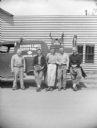
| Description: | Sigurd Olson (second from the left), his two sons on the right, and two unidentified men, thought to be wilderness guides who worked for his Border Lakes O... |
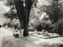
| Date: | 1925 |
|---|---|
| Description: | Children are sitting on benches looking at books, and other children are playing in a sandbox at Happy Hearts Park. |
| Date: | |
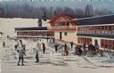
|---|---|
| Description: | Color postcard of the Chalet at Mt. Telemark. Skiers and skis are in front of the Chalet. |
| Date: | |
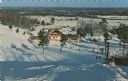
|---|---|
| Description: | Color postcard of an elevated view of the Chalet at Mt. Telemark and surrounding area, and many skiers and several ski lifts. |
| Date: | |
|---|---|
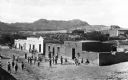
| Description: | Elevated view of children playing outside adobe homes in a residential area. |

| Date: | |
|---|---|
| Description: | View of children playing at the Zabriskie Playground outside Number Nine Public School. The playground is found at the intersection of Mercer and Wayne St... |

| Date: | 1936 |
|---|---|
| Description: | This pictorial tourist map from the Wisconsin Conservation Commission depicts vacation activities and identifies tourist destinations throughout the state.... |

| Date: | 05 14 1957 |
|---|---|
| Description: | Hariett Narowetz and Irene L. Marsh pull their golf bags across the golf course. |

| Date: | 08 31 1979 |
|---|---|
| Description: | A young couple enjoys each other's company among others on a beautiful day at Library Mall on the campus of UW-Madison. |

| Date: | 1948 |
|---|---|
| Description: | This colored road map shows automobile roads in Wisconsin as well as portions of nearby states.Information on the quality and type of any road shown (bitum... |

| Date: | 1971 |
|---|---|
| Description: | This colored map displays Wisconsin and bordering areas of Iowa, Minnesota, and Michigan. There is color-coding on the map to indicate National Forests, an... |

| Date: | 1973 |
|---|---|
| Description: | This colored map displays Wisconsin and bordering areas of Iowa, Minnesota, and Michigan. There is color-coding on the map to indicate National Forests, a... |

| Date: | 1975 |
|---|---|
| Description: | This colored road map of Wisconsin displays "Featured Points of Interest" and "Historical Points of Interest" in the state, including three color photograp... |

| Date: | 1976 |
|---|---|
| Description: | This colored map displays Wisconsin and portions of bordering states, including a detailed map of the Wisconsin Dells area. Surrounding the map are multipl... |

| Date: | 1977 |
|---|---|
| Description: | This colored map displays Wisconsin and portions of bordering states, including a detailed map of the Wisconsin Dells area. Surrounding the map are multipl... |

| Date: | 1980 |
|---|---|
| Description: | The general theme of this black and white map is "Discover and Enjoy Wisconsin." The front of the map depicts driving tours numbered 1 through 12; each to... |

| Date: | 1948 |
|---|---|
| Description: | Slightly elevated view of two men snowshoeing along a flowing stream near Trout Lake. |

| Date: | 1946 |
|---|---|
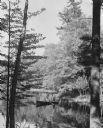
| Description: | Two canoes are pulled up on the shoreline in the Flambeau River State Forest. |
| Date: | 1950 |
|---|---|
| Description: | Two men fishing in a rowboat powered by a trolling motor. They are framed by two trees on the shore of Crab Lake. |
| Date: | 1956 |
|---|---|
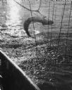
| Description: | A fish is scooped in a net after being caught with a fishing pole at Twin Lakes. |
If you didn't find the material you searched for, our Library Reference Staff can help.
Call our reference desk at 608-264-6535 or email us at: