 Filter: Categories of Wisconsin Historical Images
Filter: Subject of Oneida Indians
Filter: Year of 1800-1899
Filter: Categories of Wisconsin Historical Images
Filter: Subject of Oneida Indians
Filter: Year of 1800-1899

| Date: | 1878 |
|---|---|
| Description: | A hand-colored, cloth mounted, sectional map of Wisconsin and the western portion of Michigan’s Upper Peninsula, showing the township grid, railroads, town... |

| Date: | 1880 |
|---|---|
| Description: | A hand-colored, sectional map of Wisconsin showing the township grid, railroads, counties, towns, cities, villages, and the Menomonee, Oneida, Flambeau, an... |

| Date: | 1882 |
|---|---|
| Description: | A hand-colored, sectional map of Wisconsin showing the township grid, completed and proposed railroads, counties, towns, cities, villages. The map also inc... |

| Date: | 1872 |
|---|---|
| Description: | Microfilmed page from John Archiquette's diary partially written in the Oneida language. |

| Date: | 1898 |
|---|---|
| Description: | This 1898 map of Outagamie County, Wisconsin, shows the township and range grid, towns, sections, cities and villages, the Oneida Reservation, landownershi... |
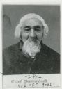
| Date: | 1875 |
|---|---|
| Description: | Portrait of Chief Elijah Skenandoah, a Turtle Clan chief of the Oneida nation. He moved to Wisconsin from New York in the 1830s, along with a group of Onei... |
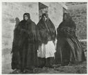
| Date: | 1899 |
|---|---|
| Description: | Group portrait of three women standing outside against a brick building. All three women are wearing dresses, with shawls covering their shoulders and head... |
If you didn't find the material you searched for, our Library Reference Staff can help.
Call our reference desk at 608-264-6535 or email us at: