 Filter: Categories of Wisconsin Historical Images
Filter: Subject of Oneida Indians
Filter: Subject of human settlements
Filter: County of Outagamie
Filter: Categories of Wisconsin Historical Images
Filter: Subject of Oneida Indians
Filter: Subject of human settlements
Filter: County of Outagamie

| Date: | 1898 |
|---|---|
| Description: | This 1898 map of Outagamie County, Wisconsin, shows the township and range grid, towns, sections, cities and villages, the Oneida Reservation, landownershi... |
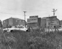
| Date: | 1967 |
|---|---|
| Description: | View of signs in a field near a damaged car. There are buildings in the background. Signs read: "yonʌyode ˀagá People of the Red Stone," "Oneida ... |
If you didn't find the material you searched for, our Library Reference Staff can help.
Call our reference desk at 608-264-6535 or email us at: